Hirzenhain
| Hirzenhain | ||
|---|---|---|
 Hirzenhain in 2009 | ||
| ||
 Hirzenhain Location of Hirzenhain within Wetteraukreis district 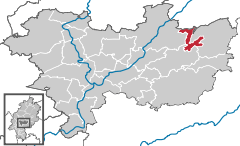  | ||
| Coordinates: 50°23′25″N 9°8′10″E / 50.39028°N 9.13611°ECoordinates: 50°23′25″N 9°8′10″E / 50.39028°N 9.13611°E | ||
| Country | Germany | |
| State | Hesse | |
| Admin. region | Darmstadt | |
| District | Wetteraukreis | |
| Government | ||
| • Mayor | Freddy Kammer | |
| Area | ||
| • Total | 16.11 km2 (6.22 sq mi) | |
| Elevation | 260 m (850 ft) | |
| Population (2017-12-31)[1] | ||
| • Total | 2,882 | |
| • Density | 180/km2 (460/sq mi) | |
| Time zone | CET/CEST (UTC+1/+2) | |
| Postal codes | 63697 | |
| Dialling codes | 06045 | |
| Vehicle registration | FB | |
| Website | www.hirzenhain.de | |

Hirzenhain is a municipality in the Wetteraukreis, in Hesse, Germany. It is located approximately 45 kilometers northeast of Frankfurt am Main. It has a population of around 2,800.
History
From 1943 to 1945 the area was the site of de:Arbeitserziehungslager Hirzenhain, a camp for forced labourers run by the Gestapo. On 25 March 1945, shortly before the end of the war, a troop of SS killed 87 inmates of the camp. There is a memorial to the victims in the municipality. The dead were reinterred at Arnsburg Abbey in 1960.[2]
References
- ↑ "Bevölkerung der hessischen Gemeinden". Hessisches Statistisches Landesamt (in German). September 2018.
- ↑ Sundermann, Detlef (26 March 2010). "SS-Massenmord kurz vor Kriegsende(German)". Frankfurter Rundschau. Retrieved 15 January 2017.
External links
| Wikimedia Commons has media related to Hirzenhain. |
Towns and municipalities in Wetteraukreis district | ||
|---|---|---|
This article is issued from
Wikipedia.
The text is licensed under Creative Commons - Attribution - Sharealike.
Additional terms may apply for the media files.