Florstadt
| Florstadt | ||
|---|---|---|
| ||
 Florstadt Location of Florstadt within Wetteraukreis district 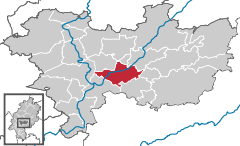  | ||
| Coordinates: 50°18′57″N 8°51′47″E / 50.31583°N 8.86306°ECoordinates: 50°18′57″N 8°51′47″E / 50.31583°N 8.86306°E | ||
| Country | Germany | |
| State | Hesse | |
| Admin. region | Darmstadt | |
| District | Wetteraukreis | |
| Government | ||
| • Mayor | Herbert Unger (SPD) | |
| Area | ||
| • Total | 39.60 km2 (15.29 sq mi) | |
| Elevation | 156 m (512 ft) | |
| Population (2017-12-31)[1] | ||
| • Total | 8,702 | |
| • Density | 220/km2 (570/sq mi) | |
| Time zone | CET/CEST (UTC+1/+2) | |
| Postal codes | 61197 | |
| Dialling codes |
06035, 06041 (Nieder-Mockstadt) | |
| Vehicle registration | FB | |
| Website | www.florstadt.de | |

Florstadt is a town in the Wetteraukreis, in Hesse, Germany. It is located approximately 26 kilometers northeast of Frankfurt am Main. It received town privileges in 2007.
Rivers
The river Nidda and its tributary the Horloff flow through the area of the town.
Location
Florstadt borders on the town Reichelsheim in the north, on Ranstadt in the northeast, on Glauburg in the east, on Altenstadt and Niddatal in the south, and on Friedberg in the west.
Districts
The town is divided into 6 districts: Leidhecken, Nieder-Florstadt, Nieder-Mockstadt, Ober-Florstadt, Staden, and Stammheim.
Towns and municipalities in Wetteraukreis district | ||
|---|---|---|
References
- ↑ "Bevölkerung der hessischen Gemeinden". Hessisches Statistisches Landesamt (in German). September 2018.
This article is issued from
Wikipedia.
The text is licensed under Creative Commons - Attribution - Sharealike.
Additional terms may apply for the media files.