Hinjawadi
| Hinjawadi | |
|---|---|
| Suburb | |
 Hinjawadi Location in Maharashtra, India | |
| Coordinates: 18°35′41″N 73°43′07″E / 18.594596°N 73.718519°ECoordinates: 18°35′41″N 73°43′07″E / 18.594596°N 73.718519°E | |
| Country |
|
| State | Maharashtra |
| District | Pune |
| Taluka | Mulshi |
| Government | |
| • Body | Gram Panchayat |
| Languages | |
| • Official | Marathi |
| Time zone | UTC+5:30 (IST) |
| PIN | 411057 |
| Telephone code | 91-(0)-20 |
| Vehicle registration | MH-12 |
Hinjawadi is a suburb located in Pune, Maharashtra, India. It is off the Dehu Road–Katraj bypass on the western side of Wakad in Pune. It is mainly known for the Rajiv Gandhi Infotech Park (which also extends to adjacent Maan and Marunji). The 2800-acre IT park in Hinjawadi, Maan and Marunji, houses hundreds of companies of different sizes.[1]
History
Hinjawadi was a completely rural locale until the construction of the Rajiv Gandhi Infotech Park. The park comprises three phases with further phases planned. Hinjawadi Industries Association(HIA) was laid out to provide a joint forum to all stakeholders based out of Hinjawadi and nearby places.
Hinjawadi is a proposed hub for integrated townships in Pune.[2] The new Special Township Policy Act of the Maharashtra government has laid down an integrated approach to development of townships to de-congest Pune Municipal Corporation areas and encourage new settlements in its periphery though higher FSI (floor space index) than what is normally allowed in the municipal limits.
Transport
Road Transport
Due to rapid development, Hinjawadi is facing serious traffic problems during peak hours. From 8.00 AM to 12:00 PM and 5.30 PM to 7.30 PM, HMVs (Heavy Motor Vehicles) are not allowed to enter the area due to high congestion on the roads and the number of vehicles are increasing due to a lot of career opportunities. Above 2.5 Lacs employees travel daily to and from the IT park.[3] Recently, the traffic cops have designated several approach points as one-way to ease the traffic congestion which has helped to a certain extent.
Metro
Pune Metropolitan Region Development Authority (PMRDA[4]) has suggested a metro route between Hinjawadi and Shivajinagar.[5] The line will travel through PMC, PCMC and MIDC areas.
Security
MIDC (Maharashtra Industrial Development Corporation) took special initiative to install closed circuit television camera project. The project, co-sponsored by the Maharashtra Industrial Development Corporation (MIDC) and the Hinjawadi Industries Association, has 22 surveillance cameras monitoring the activity at six junctions in the IT Park. It is integrated with the Rs 225-crore CCTV camera project (1,285 cameras at 441 junctions) coming up in the city. The output is monitored and recorded by the centralized unit at the Pune Police Commissionerate.
Colleges
- International Institute of Information Technology, Pune, Hinjewadi
- Symbiosis International University, Hinjewadi
- ALARD Group of Institutes, Marunji
- INTERNATIONAL INSTITUTE OF MANAGEMENT STUDIES, Nere
Schools
- Mercedes-Benz International School
- Blue Ridge Public School [6]
- Pawar Public School [7]
- VIBGYOR High School [8]
- SPORTSLIFE Football School [9]
Gallery
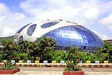 Infosys, Hinjawadi Phase-2
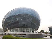 Infosys, Hinjawadi Phase-2
 Cognizant, Hinjawadi Phase-1
 Embassy Tech Zone, Hinjawadi Phase-2
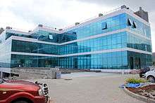 Fulcrum Worldwide, Maan Phase-3
Geography
See also
References
- ↑ Banerjee, Shoumojit (27 May 2017). "Pune, where panic reigns an IT campus". The Hindu. Retrieved 2 August 2018.
- ↑ "Integrated townships in Pune — Moneycontrol.com". moneycontrol.com. Retrieved 2014-01-30.
- ↑ "Commuters heave a sigh of relief after one-way traffic eases congestion in Hinjewadi".
- ↑ "Pune Metropolitan Regional Development Authority - PMRDA | Government Organization | India | eListing.in". eListing.in. Retrieved 2017-10-13.
- ↑ http://indianexpress.com/article/cities/pune/pmrda-proposes-metro-line-from-shivajinagar-to-hinjewadi/
- ↑ Blue Ridge Public School, Blue Ridge Public School, retrieved 26 February 2017
- ↑ Pawar Public School, Pawar Public School, retrieved 26 February 2017
- ↑ "VIBGYOR HIGH Hinjawadi".
- ↑ SPORTSLIFE Football School, SPORTSLIFE Football School, retrieved 26 February 2017