Hingangaon (Kavathe Mahankal)
| Hingangaon | |
|---|---|
| Village | |
 Hingangaon Location in Maharashtra, India | |
| Coordinates: 16°58′48.9″N 74°51′35.7″E / 16.980250°N 74.859917°ECoordinates: 16°58′48.9″N 74°51′35.7″E / 16.980250°N 74.859917°E | |
| Country |
|
| State | Maharashtra |
| District | Sangli |
| Established | 1 April 1922 |
| Named for | हिंगणमिटकाची झाडे |
| Government | |
| • Type | Gram panchayat |
| • Body | Gram Panchayat |
| Population (2011) | |
| • Total | 4,832 |
| Languages | |
| • Official | Marathi |
| Time zone | UTC+5:30 (IST) |
| PIN | 416405 |
Hingangaon is a village and Gram panchayat in Kavathe Mahankal, Sangli of Maharashtra, India. It is located near the Maharashtra-Karnataka border and is approximately 10 km from the Miraj-Pandharpur highway, 50 km from Sangli........
Location
Hingangaon is situated on the banks of the river Agrani(अग्रणी).
Demography
According to 2011 census:
Population: 4832
Family 1035
Sex ratio: 999
Literacy: 83.34%
Children(0-6 age): 455 (9.42%)
Child Sex ratio: 827
Art and culture
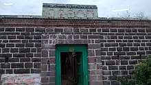
Hingangaon having old style fortified house call "wada" in Marathi still are there some old fortified house.
Hingangaon is femous for God Vithala parayan festival which is part of 15th century bhaki movement in Maharashtra
Climate
Hingangaon has a semi-arid climate with three seasons, a hot, dry summer from the middle of February to the middle of June, a monsoon from the middle of June to late October and a mild cool season from early November to early February. The total rainfall is about 22 inches (580 mm).
Schools
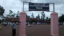
- Shri Narayan Tatoba Sagare Vidyalaya, Hingangaon.(S.N.T.S.V.H.)
- Zilha Parishad Primary School, Hingangaon
Transport
Transport is mainly carried by the government buses of M.S.R.T.C. via two main centres viz. Kavathe Mahankal and Miraj. Some private means like taxis, trucks are also available. Locals use bicycles, two-wheelers and four-wheelers.
- Air : Nearest airport is Kolhapur but not fully integrated for domestic flight, therefore Pune is nearest Airport about 250 km away.
- Rail : Nearest railway station is in Kavathe Mahankal about 15 km away.
- Road : Roads are good. Road connectivity is good especially to Kavathe Mahankal and Athani(KA) (via सलगरे)
See also
References