Hillcrest, Illinois
| Hillcrest, Illinois | |
|---|---|
| Village | |
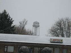 The Hillcrest water tower looms over a small business in the foreground | |
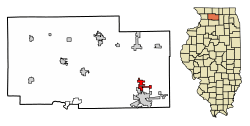 Location of Hillcrest in Ogle County, Illinois. | |
 Hillcrest, Illinois Location within Ogle County  Hillcrest, Illinois Hillcrest, Illinois (Illinois) | |
| Coordinates: 41°57′11″N 89°04′06″W / 41.95306°N 89.06833°WCoordinates: 41°57′11″N 89°04′06″W / 41.95306°N 89.06833°W | |
| Country | United States |
| State | Illinois |
| County | Ogle |
| Township | Flagg |
| Area[1] | |
| • Total | 3.20 sq mi (8.29 km2) |
| • Land | 3.20 sq mi (8.29 km2) |
| • Water | 0.00 sq mi (0.00 km2) |
| Elevation | 830 ft (250 m) |
| Population (2010) | |
| • Total | 1,326 |
| • Estimate (2016)[2] | 1,264 |
| • Density | 394.88/sq mi (152.48/km2) |
| Postal code | 61068 |
| Area code(s) | 815 |
| FIPS code | 17-34982 |
| Website |
www |
Hillcrest is a village located in Ogle County, Illinois, United States. The 2010 census lists its population at 1,326, up from 1,158 in 2000.
Geography
Hillcrest is located at 41°57′11″N 89°4′6″W / 41.95306°N 89.06833°W (41.952924, -89.068216).[3]
According to the 2010 census, Hillcrest has a total area of 3.16 square miles (8.18 km2), all land.[4]
Demographics
| Historical population | |||
|---|---|---|---|
| Census | Pop. | %± | |
| 1960 | 224 | — | |
| 1970 | 630 | 181.3% | |
| 1980 | 818 | 29.8% | |
| 1990 | 828 | 1.2% | |
| 2000 | 1,158 | 39.9% | |
| 2010 | 1,326 | 14.5% | |
| Est. 2016 | 1,264 | [2] | −4.7% |
| U.S. Decennial Census[5] | |||
At the 2000 census,[6] there were 1,158 people, 342 households and 297 families residing in the village. The population density was 2,080.8 per square mile (798.4/km²). There were 353 housing units at an average density of 634.3 per square mile (243.4/km²). The racial makeup of the village was 88.51% White, 0.35% African American, 0.60% Native American, 0.26% Asian, 9.67% from other races, and 0.60% from two or more races. Hispanic or Latino of any race were 21.24% of the population.
There were 342 households of which 52.3% had children under the age of 18 living with them, 73.7% were married couples living together, 7.9% had a female householder with no husband present, and 12.9% were non-families. 10.2% of all households were made up of individuals and 1.5% had someone living alone who was 65 years of age or older. The average household size was 3.39 and the average family size was 3.61.
Age distribution was 36.4% under the age of 18, 7.8% from 18 to 24, 33.9% from 25 to 44, 16.6% from 45 to 64, and 5.4% who were 65 years of age or older. The median age was 30 years. For every 100 females, there were 107.5 males. For every 100 females age 18 and over, there were 98.1 males.
The median household income was $49,821, and the median family income was $49,375. Males had a median income of $36,250 versus $22,885 for females. The per capita income for the village was $15,340. About 5.3% of families and 6.1% of the population were below the poverty line, including 8.6% of those under age 18 and none of those age 65 or over.
References
| Wikimedia Commons has media related to Hillcrest, Illinois. |
- ↑ "2016 U.S. Gazetteer Files". United States Census Bureau. Retrieved Jun 29, 2017.
- 1 2 "Population and Housing Unit Estimates". Retrieved June 9, 2017.
- ↑ "US Gazetteer files: 2010, 2000, and 1990". United States Census Bureau. 2011-02-12. Retrieved 2011-04-23.
- ↑ "G001 - Geographic Identifiers - 2010 Census Summary File 1". United States Census Bureau. Retrieved 2015-08-03.
- ↑ "Census of Population and Housing". Census.gov. Archived from the original on May 12, 2015. Retrieved June 4, 2015.
- ↑ "American FactFinder". United States Census Bureau. Retrieved 2008-01-31.
Municipalities and communities of Ogle County, Illinois, United States | ||
|---|---|---|
| Cities | ||
| Villages | ||
| Townships | ||
| CDPs | ||
| Other unincorporated communities | ||
| Footnotes | ‡This populated place also has portions in an adjacent county or counties | |