Arkansas Highway 115
| ||||
|---|---|---|---|---|
 | ||||
| Route information | ||||
| Maintained by ArDOT | ||||
| Length | 64.8 mi[1][2][3] (104.3 km) | |||
| Major junctions | ||||
| South end |
| |||
| North end |
| |||
| Location | ||||
| Counties | Sharp, Lawrence, Randolph | |||
| Highway system | ||||
| ||||

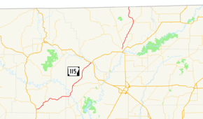
Arkansas Highway 115 is a state highway of 64.8 miles (104.3 km) that runs in Sharp, Lawrence, and Randolph Counties.[1][2][3]
Route description
AR 115 begins at US 167/AR 58 in Cave City running with AR 58 north. The route continues northeast to meet AR 117 in Smithville. AR 115 arrows north to Imboden where it meets US 62/US 63/US 412/AR 166. It runs with these routes until Pocahontas, where the route begins to angle north toward Missouri. AR 115 briefly concurs with US 67 and AR 90 in Pocahontas. The route meets AR 328 in Maynard before the Missouri state line, where it continues as Missouri Route 21.
History
The original Arkansas Highway 115 was designated in 1926, from Thornton to El Dorado. In 1935, US 79 was created in Arkansas, replacing a portion of US 167 from Thornton to Camden. Highway 7 replaced a portion of US 167 from Camden to El Dorado. US 167 was rerouted over Highway 115, and Highway 115 was instead designated on a similar route to the current route as a renumbering of Arkansas Highway 79.
See also


- List of state highways in Arkansas
References
- 1 2 Arkansas State Highway and Transportation Department. AHTD Sharp County map Retrieved on May 20, 2009.
- 1 2 Arkansas State Highway and Transportation Department. AHTD Lawrence County map Retrieved on May 20, 2009.
- 1 2 Arkansas State Highway and Transportation Department. AHTD Randolph County map Retrieved on May 20, 2009.
External links
Route map:
![]()