St Giles Circus
Coordinates: 51°30′59″N 0°07′50″W / 51.51639°N 0.13056°W
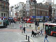
St Giles Circus is a road junction in the St Giles district of the West End of London at the eastern end of Oxford Street, where it connects with New Oxford Street, Charing Cross Road and Tottenham Court Road. It is near to Soho, Covent Garden, Bloomsbury and Fitzrovia. The word Circus is used although the buildings around the traffic junction are not all rounded, as with for example Oxford Circus.
Formation
From the Middle Ages until the fifteenth century, gallows were located at St Giles Circus alongside a cage for prisoners,[1] and a cattle enclosure known as St Giles's Pound. The area was an infamous rookery[2] until it was cleared in the mid-19th century with the creation of New Oxford Street parallel to St Giles High Street by clearances.[3]
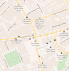
Tottenham Court Road Underground station was opened in July 1900 as part of the Central London Railway, with the platforms under Oxford Street to the west of St Giles Circus, and the station opening on the south west side of the circus, on Oxford Street.[4] The Charing Cross, Euston and Hampstead Railway joined the station with what is now part of the Northern Line in September 1908, with station entrance on the south east side of the circus.[5] The main station ticket hall was later moved underground, built below the circus in the 1920s.[6]
Modern development
The area today is dominated by Centre Point Tower, located on the south-east corner on New Oxford Street and Charing Cross Road. Built between 1963 and 1966 by developer Harry Hyams, the brutalist tower was London's first "skyscraper", and is now a Grade II listed building.[3] As part of the Centre Point project the developer was to have included a modern traffic roundabout and transport interchange, but this part of the scheme was not delivered.

St Giles Circus has been since 2009 the site of construction for Crossrail, which have disrupted road flows and led to several buildings being demolished.[7]
The Dominion Theatre is close to the north-east corner, on Tottenham Court Road just above New Oxford Street. The London Astoria theatre was on the south west side. A new theatre to replace the Astoria is planned.[8] An auditorium/gallery is planned for the south-east corner.[9]
References
- ↑ Ackroyd, Peter (2000-10-05). London: The Biography. Chatto & Windus. pp. 131–140. ISBN 9781856197168. OCLC 45325918.
- ↑ A Visit to the Rookery of St Giles and its Neighbourhood
- 1 2 "St Giles - Hidden London". hidden-london.com. Retrieved 2016-12-22.
- ↑ "Clive's Underground Line Guides – Central Line, Dates". www.davros.org. Retrieved 2016-12-22.
- ↑ Rose, Douglas (1999). The London Underground, A Diagrammatic History. Douglas Rose. ISBN 1-85414-219-4.
- ↑ Railways Through The Clay; Croome & Jackson; London; 1993; p169
- ↑ "Tottenham Court Road station". Crossrail. Retrieved 2016-12-22.
- ↑ "Crossrail plans to transform Tottenham Court Road and West End approved". Crossrail. 20 April 2012. Retrieved 23 November 2012.
- ↑ propertymall.com. "Final piece in £90m St Giles Circus development given the green light". www.propertymall.com. Retrieved 2016-12-22.