Henstead
| Henstead | |
|---|---|
 Henstead, Church of St Mary | |
 Henstead Henstead shown within Suffolk | |
| Population | 408 (2011 Census) |
| OS grid reference | TM495860 |
| District | |
| Shire county | |
| Region | |
| Country | England |
| Sovereign state | United Kingdom |
| Post town | Beccles |
| Postcode district | NR34 |
| Dialling code | 01502 |
| EU Parliament | East of England |
| UK Parliament | |
Henstead is a village near Kessingland and the A12 in the civil parish of Henstead with Hulver Street, in the county of Suffolk, England. It has a church called Church of St Mary which is a Grade I listed building.[1] It has very few housing areas, and is a rural area. It is situated near Rushmere and includes its population.
It has a very small population of just 408, and is in the district of Waveney, which contains many very similar sized civil parishes.
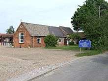
The Independent preparatory school The Old School Henstead is also located in the village.
The church has a Norman doorway, and an embattled tower. The village stands 3 miles from the coast, and 5 SE of Beccles railway station.
History
In 1771 the landscape artist, Thomas Hearne spent six weeks with the young George Beaumont in Henstead at the home of the latter's tutor at Eton, Charles Davy (a priest). For Beaumont it proved the inspiration for his future profession as a landscape painter himself.[2]
Through time, Henstead has had a history of having job opportunities mainly in agriculture, retail and handicraft.
In 1831, out of a total of 144 people, 107 worked in agriculture, 20 worked in retail and handicraft, and 17 worked in other domains.[3]
The structure of jobs in Henstead hasn't changed, it is still a rural area, with most jobs available in the agricultural domain., for example in 1881, around 130 jobs were in the agricultural domain, the highest of all sectors. This is a description from the 1870s:
The parish contains also the hamlet of Hulver, which has a post office under Beccles. Acres, 1, 918. Real property, £2, 090. Pop., 534. Houses, 120.[4]
Henstead has had a history of a poor social structure:
In 1831, 134 people lived in Henstead and 106 of those were labourers or servants.[5] There were very few occupations that offered high wages, most were in the Primary industry.
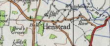
A map of Henstead from the 20th century is shown to the left.
Demographics
It had a population of 408 in 2011, according to the census in all that year.[6]
Henstead is a part of the district of Waveney. On average, the different parishes and towns in Waveney are very similar in terms of job opportunities, and population structure.
In terms of Waveney's population and its qualifications:
Waveney has 20% less Higher and Intermediate managerial qualifications, administrative qualifications than the national average.[7]
Waveney has a particularly elderly-heavy age structure, as it is a peaceful, rural area.
The population of Henstead as a whole, is older than the national average. The population of Waveney is also older than the Suffolk average, making Henstead an older persons location, much like the rest of Waveney, Waveney's mean age is 43.9, compared to the national average of 39.[8]
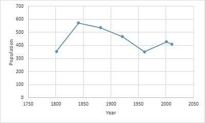
This graph illustrates how the population of Henstead has changed over time. It grew rapidly from 1800 to 1840, going from 355 to 590 in that period. It decreased steadily after this period, going from 590 in 1840 to 345 in 1960. The last census in 2011 showed the population is now 408. This shows that Henstead has always had an average population of around 400, and has never expanded into a larger civil parish, it has never experienced rapid economic growth. This is due to many factors, one of which is its lack of infrastructure, and lack of investment in services by the governing bodies of Henstead.
The number of households in Henstead has never rapidly increased, it has always stayed relatively the same; between 1900 and 1960 it has gradually increased from 110 to 122.[9]
Economy
Waveney as a district has a stable economy; despite being rural it doesn't have any particularly poor areas. Henstead is not a poor area; however, it does have issues with lack of opportunities, which creates unemployment.
The rate of unemployment in Henstead is both higher than the average for Suffolk and higher than the national average, suggesting that finding a job in this area maybe [sic] hard.[10]
Many jobs in Henstead are found through agriculture, retail and handicraft.
Waveney also has a very low level of immigration, with only 2% of their population coming from outside the EU, compared to the national average of 9.4%. This may be due to a lack of employment opportunities in Waveney, as opposed to highly populated urban areas like London.
Henstead has always had a steady economic growth, it has never experienced rapid economic growth, because its population has never rapidly increased.
Henstead only has one school; due to its low level of population, therefore it does not have a high quality of opportunities in terms of education and qualifications which can be acquired from within the area alone. Students have to go to surrounding areas to find education after a certain age. This causes an increased level of migration away from Henstead, and negatively impacts its economy.
Employment
Henstead is a rural area, therefore employment opportunities are not as high as they are in urban areas. Employment is predominantly in Agriculture, produce, and textiles. However, there are other professions, such as policing, medical services, council services, and domestic offices or services.
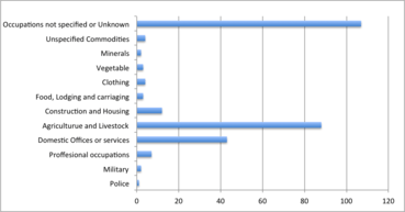
The graph to the right illustrates the amount of people engaged in various types of occupations. The majority of known occupations are in Agriculture and Livestock industries. There are very few people involved in professional occupations — only 8 are involved in this sector, compared to 88 in agriculture and livestock. There are also very few people involved in policing, due to a low level of population in this area, which leads to a low crime rate. The size of the area is also a reason for a low level of job opportunities, as it is a very small area.
References
- ↑ Historic England. "Details from image database (282054)". Images of England. Retrieved 19 June 2011.
- ↑ Felicity Owen ‘Beaumont, Sir George Howland, seventh baronet (1753–1827)’, Oxford Dictionary of National Biography, Oxford University Press, 2004
- ↑ "Henstead AP/CP through time | Industry Statistics | Males aged 20 & over, in four industrial categories". www.visionofbritain.org.uk. Retrieved 2016-03-22.
- ↑ Wilson, John Marius (1870–72). Imperial Gazetteer of England and Wales. Edinburgh: A. Fullerton & Co.
- ↑ "Henstead AP/CP through time | Social Structure Statistics | Social Status, based on 1831 occupational statistics". www.visionofbritain.org.uk. Retrieved 2016-03-22.
- ↑ "Henstead : Key figures for 2011 Census: Key Statistics". Neighbourhood Statistics. Office for National Statistics. Retrieved 28 January 2016.
- ↑ "Henstead, Suffolk". iLiveHere - Britain's worst places to live. 2012-04-16. Retrieved 2016-03-19.
- ↑ "Henstead, Suffolk". iLiveHere - Britain's worst places to live. 2012-04-16. Retrieved 2016-03-20.
- ↑ "Henstead AP/CP through time | Housing Statistics | Total Households". www.visionofbritain.org.uk. Retrieved 2016-03-22.
- ↑ "Henstead, Suffolk". iLiveHere - Britain's worst places to live. 16 April 2012. Retrieved 20 March 2016.