Frostenden
| Frostenden | |
|---|---|
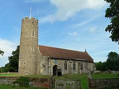 Frostenden All Saints | |
 19th Century Map of Frostenden | |
 Frostenden Frostenden shown within Suffolk | |
| Population | 167 (2011 Census) |
| Civil parish |
|
| District | |
| Shire county |
|
| Region | |
| Country | England |
| Sovereign state | United Kingdom |
| Post town | Beccles |
| Postcode district | NR34 7 |
| Dialling code | 01502 |
| Police | Suffolk |
| Fire | Suffolk |
| Ambulance | East of England |
| EU Parliament | East of England |
Frostenden is a small village and civil parish in the Waveney district, in the county of Suffolk, England. It is located around 1 mile south-west of the neighbouring town, Wrentham.[1] Its church, All Saints, is one of 38 existing round-tower churches in Suffolk. It is situated west to the A12 and can be seen from this major road.
In 1870, Frostenden was described by John Marius Wilson in the "Imperial Gazetteer of England and Wales":
The property is divided among a few. The living is a rectory in the diocese of Norwich. Value, £348. Patron, Thomas Barne, Esq. The church is chiefly early English; has a round western tower; and contains an early English piscina and a later English font. Charities, £28.[2]
Frostenden was previously part of the Blything Hundred district, a form of county division used up until the end of the 19th Century. Blything was the largest of the 21 Suffolk hundreds, and was composed of 48 parishes.[3]
Population
In 1881, the population was reported as being 386[4] but in 2011 the Frostenden population had decreased to 167.[5] According to the 2011 census there were 89 males and 78 females living in the parish.[6] As seen on the population graph below, the population has steadily declined over the past century, and as of 2011, had reached its lowest level in an official census. The highest population recorded was in the 1851 census with a total of 456 people.
Historical Population
The graph of "Recorded Historical Population of Frostenden" gives an idea of the population variation of Frostenden between the 11th and 17th centuries. The dates used are; 1086, 1327, 1524 and 1603. It is however important to note from this data that the figures given for 1327 and 1524 are representative of the total number of tax payers within the area, rather than the total net population, which would indicate the population was actually much higher.[7]
 Total Population of Frostenden Civil Parish, Suffolk, as reported by the Census of Population from 1801 to 2011.
 This graph shows the population variation of the parish of Frostenden from 4 separate dates.
Occupations over time
The 1831 census data shows a predominantly agriculture-focused population, with 70% of the workforce listed as "Agricultural Labourers", though two of the other categories can be linked to agriculture as "Farmers employing Labourers" and "Farmers not employing Labourers".[8] Maps from the 19th century show that the area was particularly rural with several farms listed within the village.
Within the population of 386 in 1881,[4] 207 of those had listed occupations on the census.[9] The main industry seen in this data was agriculture, at 33% of the total workforce — compared with less than 3% of the total workforce from the 2011 census.[10] The largest industry for the female workforce in 1881 was "Domestic Service", with 17 of the women working in this industry.[4]
 Occupational structure of the Frostenden workforce from the 1881 census data.
 Occupational structure of the Frostenden population from the 1831 census data.
All Saints Church

A key feature of Frostenden is the Round-tower church, which is now a Grade I listed building.[11] The tower is one of the oldest in Suffolk and dates back to either the Norman or Saxon era. The church however dates back to the 13th century.[12] Above the southern door to the church sits a distincitive and bright sundial, thought to be from the 18th Century, reading "vigilate et orate" meaning "Watch and Pray" in Latin. The stained glass windows of the church are much newer, dating back to the early 20th century.
The village had previously been a medieval fort, and the former river bed sits just behind the church; at the time of the Domesday Book being compiled, the village had a considerable population and two churches.
The number "1606" is scratched into one of the church walls, which could be reference to when the Dutch navigator, Willem Janszoon, reached the shores of Australia for the first time.[13]
Memorials
There are several memorials on the site of the church, for both the First World War and the Second World War. Unusually for the area, the parish lost more men during the Second World War, which is uncommon for rural areas as it indicates the population was much higher during this time.[12]
Domesday entry
The parish of Frostenden appeared within the Domesday Book in 1086. The entry listed:
Wood for 40 pigs, formerly 1 salt house, 3½ acres meadow, 1 cob, 6 cattle, 13 pigs, 60 sheep, 24 goats, 2 beehives.[7]
In contrast to modern times, however, the area was described as a sea port, indicating that the now dried-up river bed behind the church was once navigable and of a considerable size compared with today.[7] The population of Frostenden in 1086 was listed as 35.
During this time, it has also been suggested that the area had a thriving fishing industry, due to the sea port. There is evidence to suggest that the fishermen would travel down the river to the sea to catch herring along the coast; herring fishing had been a key aspect to the Anglo-Saxon economy. This also explains the presence of a salt house, as listed in the Domesday Book as an asset of the parish, as large amounts of salt would be needed to preserve the herrings they caught.[14] It has also been suggested that there would have been a dock or quay on the river in Frostenden to allow easy access for the fishing trade.[15]
Housing composition

| Parish | Detached | Semi-detached | Terraced | Flats and apartments | Caravans or mobile homes[16] |
|---|---|---|---|---|---|
| Frostenden | 37 | 30 | 12 | 0 | 1 |
The majority of the housing within the area is either detached or semi-detached, with this accounting for 83% of the total housing.
| Parish | Population | Households | % Owned outright | % Owned with a loan[17] |
|---|---|---|---|---|
| Frostenden | 167 | 80 | 56.2% | 16.2% |
The total percentage of housing owned outright, at 56.2%, is considerably higher than the average of 30.5% across the whole of England.[17]
References
- ↑ "Maps". www.bing.com. Retrieved 2017-01-26.
- ↑ Wilson, John Marius (1870–1872). Imperial Gazetteer of England and Wales. Frostenden: A. Fullerton & Co. Retrieved 27 January 2015.
- ↑ Warner, P.M. (1982). "BLYTHING HUNDRED: A Study in the Development of Settlement AD. 400-1400" (PDF).
- 1 2 3 "GB Historical GIS / University of Portsmouth, Frostenden AP/CP through time | Population Statistics | Total Population, A Vision of Britain through Time". www.visionofbritain.org.uk. Retrieved 2017-02-08.
- ↑ "Office For National Statistics, Neighbourhood Statistics, Population Density 2011". neighbourhood.statistics.gov.uk. Retrieved 27 January 2015.
- ↑ "Office For National Statistics, Neighbourhood Statistics, Sex 2011". www.neighbourhood.statistics.gov.uk. 2008-04-14. Retrieved 2017-02-08.
- 1 2 3 Service, Suffolk County Council Archaeological. "Suffolk Heritage Explorer" (PDF). heritage.suffolk.gov.uk. Retrieved 2017-03-20.
- ↑ "GB Historical GIS / University of Portsmouth, Frostenden AP/CP through time | Industry Statistics | Males aged 20 and over, in 9 occupational categories, A Vision of Britain through Time". www.visionofbritain.org.uk. Retrieved 2017-03-14.
- ↑ "Frostenden AP/CP through time, Industry Statistics, Occupation data classified into the 24 1881 "Orders", plus sex". www.visionofbritain.org.uk. Retrieved 2017-04-27.
- ↑ "Office For National Statistics, Neighbourhood Statistics, Industry 2011". www.neighbourhood.statistics.gov.uk. Retrieved 2017-04-27.
- ↑ "Church of All Saints, Frostenden, Suffolk". www.britishlistedbuildings.co.uk. Retrieved 2017-03-21.
- 1 2 "Suffolk Churches, All Saints, Frostenden". www.suffolkchurches.co.uk. Retrieved 2017-03-14.
- ↑ Noble, J. C. (2016-05-04). A Perfect Captain. Lulu.com. ISBN 9781326448509.
- ↑ North, William (2017-03-21). The Haskins Society Journal 21: 2009. Studies in Medieval History. Boydell & Brewer. ISBN 9781843835608.
- ↑ Harper-Bill, Christopher; Rawcliffe, Carole; Wilson, Richard George (2002-01-01). East Anglia's History: Studies in Honour of Norman Scarfe. Boydell Press. ISBN 9780851158785.
- ↑ "Office For National Statistics, Neighbourhood Statistics, Accommodation Type - Households, 2011". www.neighbourhood.statistics.gov.uk. 2011-03-27. Retrieved 2017-03-13.
- 1 2 "Office For National Statistics, Neighbourhood Statistics, Tenure - Households, 2011". www.neighbourhood.statistics.gov.uk. 2011-03-27. Retrieved 2017-03-13.
External links
| Wikimedia Commons has media related to Frostenden. |