Heber City Municipal Airport
| Heber City Municipal Airport Russ McDonald Field | |||||||||||
|---|---|---|---|---|---|---|---|---|---|---|---|
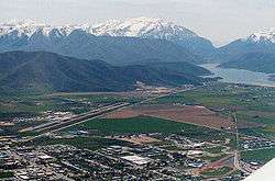 Heber valley, with the airport visible in the left portion of the valley | |||||||||||
| Summary | |||||||||||
| Airport type | Public | ||||||||||
| Owner | Heber City | ||||||||||
| Serves | Heber City, Utah | ||||||||||
| Elevation AMSL | 5,637 ft / 1,718 m | ||||||||||
| Coordinates | 40°28′54″N 111°25′44″W / 40.48167°N 111.42889°W | ||||||||||
| Website | RussMcDonaldField | ||||||||||
| Runways | |||||||||||
| |||||||||||
| Statistics (2008) | |||||||||||
| |||||||||||
Heber City Municipal Airport (ICAO: KHCR, FAA LID: HCR), also known as Russ McDonald Field, is a city-owned, public-use airport located 1 mi (2 km) south of Heber City, in Wasatch County, Utah, United States,[1] east of Salt Lake City. The airport is untowered and was activated in November 1947.[1] It is included in the National Plan of Integrated Airport Systems for 2011–2015, which categorized it as a general aviation facility.[2]
Facilities and aircraft
Heber City Municipal Airport covers an area of 401 acres (162 ha) at an elevation of 5,637 feet (1,718 m). It has one runway designated 4/22 with an asphalt surface measuring 6,899 by 75 feet with a PCN rating of 32/F/B/X/T .[1]
For the 12-month period ending December 31, 2008, the airport had 28,302 aircraft operations, an average of 77 per day: 94% general aviation, 5% air taxi, and less than 1% military. At that time there were 96 aircraft based at this airport: 69% single-engine, 6% multi-engine, 6% jet, 3% helicopter, and 16% glider.[1]
See also
References
- 1 2 3 4 5 FAA Airport Master Record for KHCR (Form 5010 PDF). Federal Aviation Administration. Effective May 31, 2012.
- ↑ "2011–2015 NPIAS Report, Appendix A" (PDF). National Plan of Integrated Airport Systems. Federal Aviation Administration. October 4, 2010. Archived from the original (PDF, 2.03 MB) on September 27, 2012. External link in
|work=(help)
External links
| Wikimedia Commons has media related to Heber City Municipal Airport. |
- Aerial image as of July 1997 from USGS The National Map
- FAA Terminal Procedures for KHCR, effective October 11, 2018
- Resources for this airport:
- FAA airport information for KHCR
- AirNav airport information for KHCR
- FlightAware airport information and live flight tracker
- SkyVector aeronautical chart for KHCR