Havana, Florida
| Havana, Florida | |
|---|---|
| Town | |
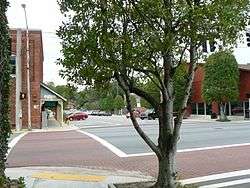 7th Ave E at U.S. Highway 27 in 2007 | |
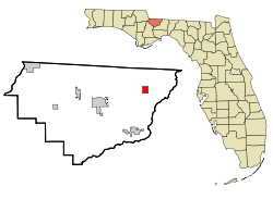 Location in Gadsden County and the state of Florida | |
| Coordinates: 30°37′27″N 84°24′54″W / 30.62417°N 84.41500°WCoordinates: 30°37′27″N 84°24′54″W / 30.62417°N 84.41500°W | |
| Country |
|
| State |
|
| County | Gadsden |
| Government | |
| • Town Manager | Howard L. McKinnon[1] |
| • Town Clerk | Shelia A. Evans[1] |
| Area[2] | |
| • Total | 2.77 sq mi (7.17 km2) |
| • Land | 2.75 sq mi (7.13 km2) |
| • Water | 0.02 sq mi (0.04 km2) |
| Elevation | 236 ft (72 m) |
| Population (2010) | |
| • Total | 1,754 |
| • Estimate (2016)[3] | 1,689 |
| • Density | 613.29/sq mi (236.83/km2) |
| Time zone | UTC-5 (Eastern (EST)) |
| • Summer (DST) | UTC-4 (EDT) |
| ZIP code | 32333 |
| Area code(s) | 850 |
| FIPS code | 12-29150[4] |
| GNIS feature ID | 0283812[5] |
| Website |
www |
Havana is a town in Gadsden County, Florida, United States, and a suburb of Tallahassee. The population was 1,754 at the 2010 census.[6] It is part of the Tallahassee Metropolitan Statistical Area.
Geography
Havana is located in northeastern Gadsden County at 30°37′27″N 84°24′54″W / 30.62417°N 84.41500°W (30.624245, -84.414955).[7] U.S. Route 27 passes through the center of town, leading southeast 16 miles (26 km) to the center of Tallahassee and north 25 miles (40 km) to Bainbridge, Georgia. Florida State Road 12 intersects US 27 in Havana; it leads west 12 miles (19 km) to Quincy, the Gadsden County seat.
According to the United States Census Bureau, Havana has a total area of 2.8 square miles (7.2 km2), of which 0.02 square miles (0.04 km2), or 0.57%, is water.[6]
Climate
| Climate data for Havana, Florida | |||||||||||||
|---|---|---|---|---|---|---|---|---|---|---|---|---|---|
| Month | Jan | Feb | Mar | Apr | May | Jun | Jul | Aug | Sep | Oct | Nov | Dec | Year |
| Record high °F (°C) | 83 (28) |
85 (29) |
90 (32) |
92 (33) |
100 (38) |
102 (39) |
102 (39) |
101 (38) |
98 (37) |
95 (35) |
87 (31) |
84 (29) |
102 (39) |
| Average high °F (°C) | 64 (18) |
67 (19) |
74 (23) |
79 (26) |
86 (30) |
90 (32) |
91 (33) |
90 (32) |
88 (31) |
81 (27) |
73 (23) |
66 (19) |
79 (26) |
| Average low °F (°C) | 40 (4) |
42 (6) |
48 (9) |
52 (11) |
61 (16) |
68 (20) |
71 (22) |
70 (21) |
66 (19) |
57 (14) |
49 (9) |
42 (6) |
56 (13) |
| Record low °F (°C) | 4 (−16) |
0 (−18) |
19 (−7) |
31 (−1) |
36 (2) |
49 (9) |
60 (16) |
59 (15) |
48 (9) |
33 (1) |
20 (−7) |
12 (−11) |
0 (−18) |
| Average precipitation inches (mm) | 4.80 (121.9) |
4.92 (125) |
5.86 (148.8) |
3.68 (93.5) |
5.04 (128) |
5.92 (150.4) |
7.36 (186.9) |
6.78 (172.2) |
4.15 (105.4) |
4.11 (104.4) |
3.51 (89.2) |
3.77 (95.8) |
59.9 (1,521.5) |
Demographics
| Historical population | |||
|---|---|---|---|
| Census | Pop. | %± | |
| 1910 | 432 | — | |
| 1920 | 448 | 3.7% | |
| 1930 | 1,169 | 160.9% | |
| 1940 | 1,221 | 4.4% | |
| 1950 | 1,634 | 33.8% | |
| 1960 | 2,090 | 27.9% | |
| 1970 | 2,022 | −3.3% | |
| 1980 | 2,782 | 37.6% | |
| 1990 | 1,654 | −40.5% | |
| 2000 | 1,713 | 3.6% | |
| 2010 | 1,754 | 2.4% | |
| Est. 2016 | 1,689 | [3] | −3.7% |
| U.S. Decennial Census[8] | |||
As of the census[4] of 2000, there were 1,713 people, 700 households, and 471 families residing in the town. The population density was 922.5 people per square mile (355.6/km²). There were 762 housing units at an average density of 410.4 per square mile (158.2/km²). The racial makeup of the town was 41.86% White, 56.74% African American, 0.06% Asian, 0.82% from other races, and 0.53% from two or more races. Hispanic or Latino of any race were 1.23% of the population.
There were 700 households out of which 26.7% had children under the age of 18 living with them, 41.1% were married couples living together, 20.6% had a female householder with no husband present, and 32.6% were non-families. 28.1% of all households were made up of individuals and 14.9% had someone living alone who was 65 years of age or older. The average household size was 2.43 and the average family size was 2.96.
In the town, the population was spread out with 22.9% under the age of 18, 8.5% from 18 to 24, 25.3% from 25 to 44, 25.2% from 45 to 64, and 18.2% who were 65 years of age or older. The median age was 40 years. For every 100 females, there were 83.2 males. For every 100 females age 18 and over, there were 79.5 males.
The median income for a household in the town was $27,344, and the median income for a family was $38,487. Males had a median income of $25,000 versus $19,958 for females. The per capita income for the town was $18,481. About 11.1% of families and 16.3% of the population were below the poverty line, including 18.3% of those under age 18 and 23.0% of those age 65 or over.
Education
The Gadsden County School District operates Havana Magnet School, which serves elementary and middle school grades. Gadsden County High School (formerly East Gadsden High School), outside of the city limits, is the only zoned high school in the county.
Previously the Havana area had three schools: Havana Elementary School, Havana Middle School, and Havana Northside High School.[9] The school began using the Accelerated School program in Spring 1995 in order to improve academic performance. In 2001 Havana Elementary, which occupied an 18-acre (7.3 ha) area, had about 100 employees and 1,000 students; most of the students were low income, and 95% of the studebnts were from African-American families.[10] In 2003 Havana Northside High School and James A. Shanks High School in Quincy consolidated into East Gadsden High.[11] In 2017 the high school section of West Gadsden High School consolidated into East Gadsden High, leaving the latter as the only remaining zoned high school in the county.[12]
Tallavanna Christian School, a private school, is in an unincorporated area near Havana.
References
- 1 2 Havana Town Organization
- ↑ "2016 U.S. Gazetteer Files". United States Census Bureau. Retrieved Jul 7, 2017.
- 1 2 "Population and Housing Unit Estimates". Retrieved June 9, 2017.
- 1 2 "American FactFinder". United States Census Bureau. Retrieved 2008-01-31.
- ↑ "US Board on Geographic Names". United States Geological Survey. 2007-10-25. Retrieved 2008-01-31.
- 1 2 "Geographic Identifiers: 2010 Demographic Profile Data (G001): Havana town, Florida". American Factfinder. U.S. Census Bureau. Retrieved November 21, 2016.
- ↑ "US Gazetteer files: 2010, 2000, and 1990". United States Census Bureau. 2011-02-12. Retrieved 2011-04-23.
- ↑ "Census of Population and Housing". Census.gov. Retrieved June 4, 2015.
- ↑ "Schools." Gadsden County School District. April 6, 2001. Retrieved on April 6, 2017.
- ↑ "HES Bio." Havana Elementary School. December 4, 2001. Retrieved on April 7, 2017.
- ↑ Miller, Brian (2017-01-30). "Striplin goes from West Gadsden to East, schools likely to consolidate". Tallahassee Democrat. Retrieved 2017-04-05.
- ↑ Jiwanmall, Stephen (2017-04-04). "Gadsden County Schools to Consolidate in 2017-18". WTXL. Retrieved 2017-04-06.
External links
| Wikimedia Commons has media related to Havana, Florida. |
Municipalities and communities of Gadsden County, Florida, United States | ||
|---|---|---|
| Cities |  | |
| Towns | ||
| Unincorporated communities | ||