Haughville, Indianapolis
|
Haughville Historic District | |
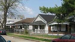 Houses on Warman Avenue | |
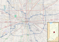   | |
| Location | Indianapolis, Indiana |
|---|---|
| Coordinates | 39°46′41″N 86°12′12″W / 39.77806°N 86.20333°WCoordinates: 39°46′41″N 86°12′12″W / 39.77806°N 86.20333°W |
| Area | 67 acres (27 ha) |
| Architect | Bedell, George |
| Architectural style | Late Victorian, Romanesque |
| NRHP reference # | 92001652[1] |
| Added to NRHP | December 9, 1992 |
Haughville is a working-class neighborhood west of downtown Indianapolis. Its borders are roughly White River Parkway to the east, Tibbs Avenue to the west, 10th Street to the north, and Michigan Street to the south. It was first settled in the 1830s and grew after a bridge was built connecting to Indianapolis, which annexed the town in 1897. Population then included Slovenian, German and Irish immigrants, among other European immigrants. In the 21st century, the neighborhood suffers from a high crime rate and low property values. It is considered one of the most impoverished neighborhoods in the city.[2]
History
A portion of the neighborhood, roughly bounded by 10th Street, Belleview Place, Walnut Street. and Concord Street, is listed on the National Register of Historic Places as the Haughville Historic District, a national historic district.[1] The district encompasses 329 contributing buildings. This area is the site of the former housing project, Concord Village.
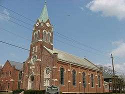
The area was first settled in the 1830s, when it became home to a number of merchants, whose small shops sprouted up near the west landing of the then brand-new Washington Street Bridge over the White River. By the 1880s, encouraged by the bridge and proximity to a number of new railroad lines, the town became home to a number of Irish, German, and later Slovene immigrants, many of whom worked in the neighborhood's two iron foundries or in meat-packing plants. The Haugh and Ketcham Iron Works gave the town its name.[3]:10 The area was incorporated in 1883 and annexed by Indianapolis in 1897. By 1900, almost half of the neighborhood's inhabitants were Slovene, many of whom attended St. Anthony's Catholic church. Due to tensions with the largely Irish population at St. Anthony's parish, the Slovenian community petitioned Vicar General Denis D. O'Donaghue to build their own church. Permission was received and Holy Trinity Slovenian Catholic Church began in April 1906. Holy Trinity is the only Slovenian Catholic church in the United States and is also an international historical landmark. It was first designated a national church, then later as a territorial church by the Catholic hierarchy. Holy Trinity eventually became home to a school, a number of local organizations and a Slovene community center. The church closed its doors in 2015. Indeed, the neighborhood's Slovene past is one of the reasons that Indianapolis has a sister-city relationship with Piran, Slovenia. The Slovenian National Home was formed in 1906 in a basement of a home across the street from Holy Trinity Slovenian Catholic Church as a place to congregate outside of church and home. Today the "Nash" is located at 2717 W. 10th street where it has been a pillar of the community since 1940. The National Home is a private club for Slovenian people, their descendants, and friends.[4] The application to be a Historic Neighborhood indicates the period of significance to be 1895 to 1942, and shows a map of the location of the area relative to Indianapolis.[5] A map of the district itself is also available.[6]
The Haughville Historic District was added to the National Register of Historic Places in 1992.[1]
Demographics
As of 2011, there were an estimated 8,043 people, a slight increase since 2000. However this represents the over Near Westside Weed and Seed incorporated, which incorporates the population of a small section of other neighborhoods surrounding Haughville. The official population of Haughville is estimated around 6,500 while the make up of Haughville (excluding Stringtown and other neighboring areas) is approximately 92 percent African-American or Black descent. The remaining percent of the area is said to be a mixture of White (Non-Hispanic) and an increasing Hispanic population.[3]
Of the adult population (25 and older), 40.7% do not have a high school diploma.[3] The overall neighborhood's per capita income is $9,760 and an average household income of $17,321 making the entire neighborhood well below the average per capita and household income of Indianapolis.[3]
Crime
Since 1992, Haughville has been a member of Indianapolis's Weed and Seed initiative, a federal program that targets high crime areas in Indianapolis and attempts to lower the amount of crime. It was the first neighborhood in Indianapolis to participate in this program. Its situation is described by the John Boner Neighborhood Centers.[7] and in a 2013 news article.[2]
According to The Indianapolis Star, Haughville had the most violent crime in the city of Indianapolis in the year 2005, with approximately 449 violent crimes taking place in Haughville. However this number is far below the record 2,589 violent crimes recorded in 1997 according to the IPD West District (This would average out to 1 out of 2.5 people being a victim of a violent offense) . During the 1990s, Haughville averaged 30 homicides a year, having the dubious honor of having one of the highest homicide rates in the nation for a neighborhood census of its size.
Education
Haughville has a public library, a branch of the Indianapolis Public Library.[8]
Notable person
- Hyapatia Lee, pornographic actress
References
- 1 2 3 National Park Service (2010-07-09). "National Register Information System". National Register of Historic Places. National Park Service.
- 1 2 Tuohy, John (August 10, 2013). "Indianapolis' killing zones: In 6 small spots, sudden, violent death is part of residents' everyday life". Indy Star. Retrieved April 25, 2016.
- 1 2 3 4 Hammerand, April (2011). "Food Assessment: Examining the Role of Food in Haughville, Indianapolis" (PDF). Legacy.Butler.Edu. Center for Urban Ecology. Retrieved August 26, 2016.
- ↑ "Indiana State Historic Architectural and Archaeological Research Database (SHAARD)" (Searchable database). Department of Natural Resources, Division of Historic Preservation and Archaeology. Retrieved August 1, 2016.
- ↑ Rollins, Suzanne T.; Smith, Jon (June 1992). "National Register of Historic Places Inventory Nomination Form: Haughville Historic District" (PDF). Retrieved August 1, 2016.
- ↑ "Site map of Haughville Historic District" (PDF). Retrieved April 25, 2017.
- ↑ "Indianapolis Neighborhoods Battle Blight, undated". Retrieved August 26, 2016.
- ↑ "Locations & Hours". Indianapolis Public Library. Retrieved 10 March 2018.
News articles
- "Authorities: We've Crippled Major Indy Drug Gang - 22 Arrested Tuesday; 23 More Sought". WRTV News 6. August 14, 2007.
- "Hovey Street Mother & Child Tied To Haughville Syndicate". Advance Indiana. January 17, 2008.
- Jefferson, Steve. "Feds arrest 22 in 'Haughville Syndicate'". WTHR News 13.

