Hattorf am Harz
| Hattorf am Harz | ||
|---|---|---|
| ||
 Hattorf am Harz Location of Hattorf am Harz within Göttingen district 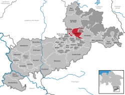 | ||
| Coordinates: 51°39′05″N 10°14′13″E / 51.65139°N 10.23694°ECoordinates: 51°39′05″N 10°14′13″E / 51.65139°N 10.23694°E | ||
| Country | Germany | |
| State | Lower Saxony | |
| District | Göttingen | |
| Municipal assoc. | Hattorf am Harz | |
| Area | ||
| • Total | 29.19 km2 (11.27 sq mi) | |
| Elevation | 176 m (577 ft) | |
| Population (2017-12-31)[1] | ||
| • Total | 4,050 | |
| • Density | 140/km2 (360/sq mi) | |
| Time zone | CET/CEST (UTC+1/+2) | |
| Postal codes | 37197 | |
| Dialling codes | 05584 | |
| Vehicle registration | GÖ, OHA | |
| Website | www.hattorfamharz.de | |

Hattorf am Harz is a municipality in the district of Göttingen, in Lower Saxony, Germany. It is situated in the southern Harz, approx. 10 km south of Osterode am Harz.
Hattorf is also the seat of the Samtgemeinde ("collective municipality") Hattorf am Harz.
Twinning
Coat of arms
The coat of arms of Hattorf exists since 1952. The gear stands for the economic of the village, the ears of corn as symbols for the agriculture of Hattorf and the red kite for nature and environment.
References
| Authority control |
|---|
This article is issued from
Wikipedia.
The text is licensed under Creative Commons - Attribution - Sharealike.
Additional terms may apply for the media files.