Bad Grund
| Bad Grund | ||
|---|---|---|
 | ||
| ||
 Bad Grund Location of Bad Grund within Göttingen district 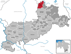 | ||
| Coordinates: 51°48′41″N 10°14′18″E / 51.81139°N 10.23833°ECoordinates: 51°48′41″N 10°14′18″E / 51.81139°N 10.23833°E | ||
| Country | Germany | |
| State | Lower Saxony | |
| District | Göttingen | |
| Government | ||
| • Mayor | Harald Dietzmann | |
| Area | ||
| • Total | 41.18 km2 (15.90 sq mi) | |
| Elevation | 295 m (968 ft) | |
| Population (2017-12-31)[1] | ||
| • Total | 8,425 | |
| • Density | 200/km2 (530/sq mi) | |
| Time zone | CET/CEST (UTC+1/+2) | |
| Postal codes | 37539 | |
| Dialling codes | 05327 | |
| Vehicle registration | GÖ, OHA | |
| Website | www.gemeinde-bad-grund.de | |

Bad Grund (Harz) is a town in the district of Göttingen, in Lower Saxony, Germany. It is situated in the western Harz, approx. 7 km west of Clausthal-Zellerfeld, and 10 km north of Osterode am Harz.
Bad Grund is also the name of the former Samtgemeinde ("collective municipality") Bad Grund, of which Bad Grund formed part. It was disbanded in March 2013 and replaced by the Einheitsgemeinde Bad Grund.
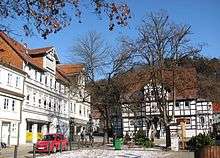
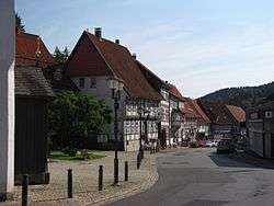
Market Place
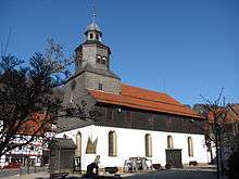
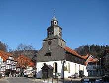
St. Antony's Church
Market Place
Points of interest
- Historic Market Place
- St. Antony's Church was built in 1540. The church is surrounded by half-timbered houses dating from the 17th, 18th and 19th centuries[2]
- WeltWald Harz
- Hübichenstein
- Hilfe Gottes Mine
- Iberger Tropfsteinhöhle
| Wikimedia Commons has media related to Bad Grund. |
References
- ↑ Landesamt für Statistik Niedersachsen, Tabelle 12411: Fortschreibung des Bevölkerungsstandes, Stand 31. Dezember 2017
- ↑ G. Ulrich Großmann: Hannover und Südniedersachsen, p. 189. Köln 1999.
| Authority control |
|---|
This article is issued from
Wikipedia.
The text is licensed under Creative Commons - Attribution - Sharealike.
Additional terms may apply for the media files.