Hattgenstein
| Hattgenstein | ||
|---|---|---|
| ||
 Hattgenstein Location of Hattgenstein within Birkenfeld district 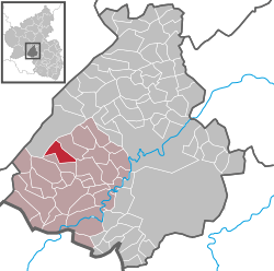 | ||
| Coordinates: 49°41′55″N 7°09′37″E / 49.69861°N 7.16028°ECoordinates: 49°41′55″N 7°09′37″E / 49.69861°N 7.16028°E | ||
| Country | Germany | |
| State | Rhineland-Palatinate | |
| District | Birkenfeld | |
| Municipal assoc. | Birkenfeld | |
| Government | ||
| • Mayor | Rudi Gordner | |
| Area | ||
| • Total | 8.21 km2 (3.17 sq mi) | |
| Elevation | 534 m (1,752 ft) | |
| Population (2017-12-31)[1] | ||
| • Total | 258 | |
| • Density | 31/km2 (81/sq mi) | |
| Time zone | CET/CEST (UTC+1/+2) | |
| Postal codes | 55767 | |
| Dialling codes | 06782 | |
| Vehicle registration | BIR | |

Hattgenstein is an Ortsgemeinde – a municipality belonging to a Verbandsgemeinde, a kind of collective municipality – in the Birkenfeld district in Rhineland-Palatinate, Germany. It belongs to the Verbandsgemeinde of Birkenfeld, whose seat is in the like-named town.
Geography
Location
The municipality lies at the edge of the Schwarzwälder Hochwald (forest) in the Hunsrück, and 72.2% of the municipal area is wooded. There is a widespread misconception that Hattgenstein, with its average elevation of 534 m above sea level, is the highest place in Rhineland-Palatinate, but this is not true. There are a few places, such as Stein-Neukirch in the High Westerwald and Nürburg in the Eifel, that are higher.[2]
Neighbouring municipalities
To the northeast lies Schwollen, and to the south, Oberhambach.
Constituent communities
Also belonging to Hattgenstein are the outlying homesteads of Helmhof, Waldfriede and Zur Zimmerei.[3]
Politics
Municipal council
The council is made up of 6 council members, who were elected by majority vote at the municipal election held on 7 June 2009, and the honorary mayor as chairman.[4]
Mayor
Since 1984, Hattgenstein’s mayor has been Rudi Gordner, and his deputy is Günter Helm.[5]
Coat of arms
The municipality’s arms might in English heraldic language be described thus: Over a base countercompony gules and argent, gules on a mount vert the Hattgenstein Glockenhaus argent with timber framing sable and doors and windows of the field.
Culture and sightseeing
Buildings
The following are listed buildings or sites in Rhineland-Palatinate’s Directory of Cultural Monuments:[6]
- Am Brunnen 2 – Quereinhaus (a combination residential and commercial house divided for these two purposes down the middle, perpendicularly to the street), partly timber-frame, partly slated, late 18th or early 19th century
- Am Brunnen 4 – former winepress house, timber-frame building
- Flurstraße 3 – Quereinhaus, partly timber-frame, possibly from the earlier half of the 19th century
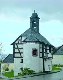
- Hauptstraße 13 – so-called Glockenhaus (“Bell House”); partly timber-frame, half-hipped roof, bell turret, 1762; characterizes village’s appearance
- Hauptstraße 17 – stately Quereinhaus, partly timber-frame, possibly from the early 19th century
The Glockenhaus (“Bell House”) is Hattgenstein’s main landmark. It was built in 1762 as a school building and a dwelling for the beadle.
Natural monuments
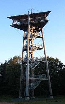
Hattgensteiner Fels, a crag with a lookout tower near the sporting ground, is believed to be the village’s namesake.
Economy and infrastructure
Transport
To the west runs Bundesstraße 269, and to the south, the Autobahn A 62 (Kaiserslautern–Trier). Available in nearby Neubrücke is a railway station on the Nahe Valley Railway (Bingen–Saarbrücken).
References
- ↑ Statistisches Landesamt Rheinland-Pfalz "Bevölkerungsstand 2017 - Gemeindeebene" Check
|url=value (help). Statistisches Landesamt Rheinland-Pfalz (in German). 2018. - ↑ Elevation misconception
- ↑ Statistisches Landesamt Rheinland-Pfalz – Amtliches Verzeichnis der Gemeinden und Gemeindeteile Archived 2015-11-25 at the Wayback Machine., Seite 19 (PDF)
- ↑ Kommunalwahl Rheinland-Pfalz 2009, Gemeinderat
- ↑ Hattgenstein’s council
- ↑ Directory of Cultural Monuments in Birkenfeld district
External links
| Wikimedia Commons has media related to Hattgenstein. |
- Municipality’s official webpage (in German)