Hattenhofen, Bavaria
| Hattenhofen | ||
|---|---|---|
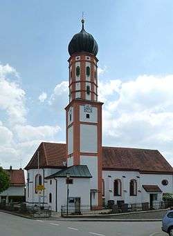 Church in Hattenhofen | ||
| ||
 Hattenhofen Location of Hattenhofen within Fürstenfeldbruck district 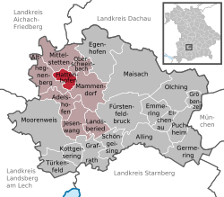 | ||
| Coordinates: 48°13′11″N 11°07′00″E / 48.21972°N 11.11667°ECoordinates: 48°13′11″N 11°07′00″E / 48.21972°N 11.11667°E | ||
| Country | Germany | |
| State | Bavaria | |
| Admin. region | Oberbayern | |
| District | Fürstenfeldbruck | |
| Municipal assoc. | Mammendorf | |
| Government | ||
| • Mayor | Franz Robeller (UWG) | |
| Area | ||
| • Total | 7.17 km2 (2.77 sq mi) | |
| Elevation | 556 m (1,824 ft) | |
| Population (2017-12-31)[1] | ||
| • Total | 1,520 | |
| • Density | 210/km2 (550/sq mi) | |
| Time zone | CET/CEST (UTC+1/+2) | |
| Postal codes | 82285 | |
| Dialling codes | 08145 | |
| Vehicle registration | FFB | |
| Website | www.hattenhofen-haspelmoor.de | |
.svg.png)
Hattenhofen is a municipality in the district of Fürstenfeldbruck in Bavaria in Germany.
References
- ↑ "Fortschreibung des Bevölkerungsstandes". Bayerisches Landesamt für Statistik und Datenverarbeitung (in German). September 2018.
Towns and municipalities in Fürstenfeldbruck district | ||
|---|---|---|
This article is issued from
Wikipedia.
The text is licensed under Creative Commons - Attribution - Sharealike.
Additional terms may apply for the media files.