Hatchechubbee, Alabama
| Hatchechubbee, Alabama | |
|---|---|
| Unincorporated community | |
 Hatchechubbee, Alabama  Hatchechubbee, Alabama | |
| Coordinates: 32°16′15″N 85°16′33″W / 32.27083°N 85.27583°WCoordinates: 32°16′15″N 85°16′33″W / 32.27083°N 85.27583°W | |
| Country | United States |
| State | Alabama |
| County | Russell |
| Elevation | 318 ft (97 m) |
| Time zone | UTC-6 (Central (CST)) |
| • Summer (DST) | UTC-5 (CDT) |
| ZIP code | 36858 |
| Area code(s) | 334 |
| GNIS feature ID | 119839[1] |
Hatchechubbee is an unincorporated community in Russell County, Alabama, United States. Hatchechubbee is located at the junction of Alabama State Route 26 and County Route 65, 6.5 miles (10.5 km) west-southwest of Seale.[2] Hatchechubbee has a post office with ZIP code 36858, which opened on August 17, 1855.[3][4]
Demographics
| Historical population | |||
|---|---|---|---|
| Census | Pop. | %± | |
| 1880 | 148 | — | |
| U.S. Decennial Census[5] | |||
Hatchechubbee appeared on the 1880 U.S. Census as having 148 residents. This was the only time it was listed on the census rolls as a separate community.
Notable person
- Holland Smith, United States Marine Corps General and "father" of modern U.S. amphibious warfare
References
- ↑ "Hatchechubbee". Geographic Names Information System. United States Geological Survey.
- ↑ Russell County, Alabama General Highway Map (PDF) (Map). Alabama Department of Transportation. 2003. Retrieved March 11, 2012.
- ↑ United States Postal Service (2012). "USPS - Look Up a ZIP Code". Retrieved 2012-02-15.
- ↑ "Postmaster Finder - Post Offices by ZIP Code". United States Postal Service. Retrieved March 11, 2012.
- ↑ "U.S. Decennial Census". Census.gov. Retrieved June 6, 2013.
Municipalities and communities of Russell County, Alabama, United States | ||
|---|---|---|
| City | 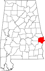 | |
| Town | ||
| CDP | ||
| Unincorporated communities | ||
| Former city | ||
| Footnotes | ‡This populated place also has portions in an adjacent county or counties | |
This article is issued from
Wikipedia.
The text is licensed under Creative Commons - Attribution - Sharealike.
Additional terms may apply for the media files.