Cottonton, Alabama
| Cottonton , Alabama | |
|---|---|
| Unincorporated community | |
 Cottonton
, Alabama  Cottonton
, Alabama | |
| Coordinates: 32°08′49″N 85°04′26″W / 32.14694°N 85.07389°WCoordinates: 32°08′49″N 85°04′26″W / 32.14694°N 85.07389°W | |
| Country | United States |
| State | Alabama |
| County | Russell |
| Elevation | 220 ft (70 m) |
| Population | 136 |
| Time zone | UTC-6 (Central (CST)) |
| • Summer (DST) | UTC-5 (CDT) |
| ZIP code | 36851 |
| Area code(s) | 334 |
| GNIS feature ID | 116693[1] |
Cottonton is an unincorporated community in Russell County, Alabama, United States. Cottonton is located along County Route 4 near Alabama State Route 165, 11.8 miles (19.0 km) south-southeast of Seale.[2] Cottonton has a post office with ZIP code 36851.[3]
Notable person
- J. C. Hartman, former Major League Baseball player
Climate
The climate in this area is characterized by hot, humid summers and generally mild to cool winters. According to the Köppen Climate Classification system, Cottonton has a humid subtropical climate, abbreviated "Cfa" on climate maps. [4]
Gallery
Below are photographs taken in Cottonton as part of the Historic American Buildings Survey:
- Well sweep, Cliatt Plantation
- Old mule gin house, Cliatt Plantation
References
- ↑ "Cottonton". Geographic Names Information System. United States Geological Survey.
- ↑ Russell County, Alabama General Highway Map (PDF) (Map). Alabama Department of Transportation. 2003. Retrieved March 11, 2012.
- ↑ United States Postal Service (2012). "USPS - Look Up a ZIP Code". Retrieved 2012-02-15.
- ↑ Climate Summary for Cottonton, Alabama
Municipalities and communities of Russell County, Alabama, United States | ||
|---|---|---|
| City | 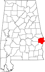 | |
| Town | ||
| CDP | ||
| Unincorporated communities | ||
| Former city | ||
| Footnotes | ‡This populated place also has portions in an adjacent county or counties | |
This article is issued from
Wikipedia.
The text is licensed under Creative Commons - Attribution - Sharealike.
Additional terms may apply for the media files.