Harviell, Missouri
| Harviell, Missouri | |
|---|---|
| Census-designated place & unincorporated community | |
 Harviell Location of Harviell, Missouri | |
| Coordinates: 36°39′53″N 90°28′20″W / 36.66472°N 90.47222°WCoordinates: 36°39′53″N 90°28′20″W / 36.66472°N 90.47222°W[1] | |
| Country | United States |
| State | Missouri |
| County | Butler |
| Township | Beaver Dam |
| Area | |
| • Total | 1.78 sq mi (4.60 km2) |
| • Land | 1.76 sq mi (4.57 km2) |
| • Water | 0.02 sq mi (0.04 km2) |
| Elevation[1] | 318 ft (97 m) |
| Population (2010) | |
| • Total | 106 |
| • Density | 60/sq mi (23.2/km2) |
| Time zone | UTC-6 (Central (CST)) |
| • Summer (DST) | UTC-5 (CDT) |
| ZIP code | 63945 |
| Area code(s) | 573 |
| FIPS code | 29-30844[2] |
Harviell is an unincorporated community and census-designated place in Butler County, Missouri, United States. As of the 2010 census it had a population of 106.[3]
History
Harviell was founded in 1873 and is named for Simeon Harviell, an early citizen.[4] A post office called Harviell has been in operation since 1874.[5]
Geography
Harviell is located on Missouri Route 158 about 10 miles (16 km) southwest of Poplar Bluff.
According to the United States Census Bureau, the CDP has a total area of 1.8 square miles (4.6 km2), of which 0.015 square miles (0.04 km2), or 0.78%, is water.[3]
References
- 1 2
- ↑ "American FactFinder". United States Census Bureau. Retrieved 2008-01-31.
- 1 2 "Geographic Identifiers: 2010 Demographic Profile Data (G001): Harviell CDP, Missouri". U.S. Census Bureau, American Factfinder. Retrieved January 23, 2014.
- ↑ "Butler County Place Names, 1928–1945 (archived)". The State Historical Society of Missouri. Archived from the original on 24 June 2016. Retrieved 6 September 2016.
- ↑ "Post Offices". Jim Forte Postal History. Retrieved 6 September 2016.
Municipalities and communities of Butler County, Missouri, United States | ||
|---|---|---|
| Cities | 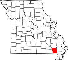 | |
| Townships | ||
| CDP | ||
| Other unincorporated communities | ||
| Ghost town | ||
| Footnotes | ‡This populated place also has portions in an adjacent county or counties | |
This article is issued from
Wikipedia.
The text is licensed under Creative Commons - Attribution - Sharealike.
Additional terms may apply for the media files.