Harrisville Rural District
|
Harrisville Rural District | |
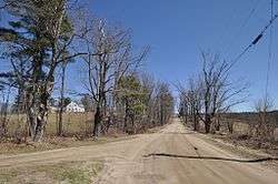 Mason Rd. | |
  | |
| Location |
Harrisville, New Hampshire Roughly along Venable, Old Harrisville, New Harrisville, and Bonds Corner Rds. |
|---|---|
| MPS | Harrisville MRA |
| NRHP reference # | 86003078[1] |
| Added to NRHP | February 18, 1987 |
The Harrisville Rural District in Harrisville, New Hampshire was listed on the National Register of Historic Places in 1987. The district encompasses a large area in the central southern part of the town, where much of its early development took place. Its westernmost public point is the corner of Mason and Macveagh Roads, and it extends eastward from there, encompassing properties that abut Mason, Venable, and New Harrisville Roads south to the town line with Dublin. Further east it encompasses properties on Bonds Corner Road between Eastview and Lampman Roads, as well as some property on the north side of Lampman Road.[2]
The district includes existing houses and outbuildings as well as foundational and archaeological remnants of previous early settlement structures. A portion of the district along New Harrisville and Venable Roads is overlaid by the Beech Hill Summer Home District.[2]
See also
- Harrisville Historic District, a later mill village and a National Historic Landmark
- National Register of Historic Places listings in Cheshire County, New Hampshire
References
| Wikimedia Commons has media related to Harrisville Rural District. |
- ↑ National Park Service (2007-01-23). "National Register Information System". National Register of Historic Places. National Park Service.
- 1 2 "NRHP nomination for Harrisville Rural District". National Park Service. Retrieved 2014-04-12.
| Topics |  | |
|---|---|---|
| Lists by county | ||
| Other lists | ||
| ||