Harold, Florida
| Harold, Florida | |
|---|---|
| Unincorporated community | |
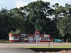 The Harold Store in Harold, Florida. | |
 Harold, Florida  Harold, Florida | |
| Coordinates: 30°39′33″N 86°52′49″W / 30.65917°N 86.88028°WCoordinates: 30°39′33″N 86°52′49″W / 30.65917°N 86.88028°W | |
| Country | United States |
| State | Florida |
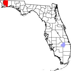
| County | Santa Rosa |
| Area[1] | |
| • Total | 14.729 sq mi (38.15 km2) |
| • Land | 14.689 sq mi (38.04 km2) |
| • Water | 0.040 sq mi (0.10 km2) |
| Elevation | 148 ft (45 m) |
| Population (2010)[1] | |
| • Total | 823 |
| • Density | 56/sq mi (22/km2) |
| Time zone | UTC-6 (Central (CST)) |
| • Summer (DST) | UTC-5 (CDT) |
| Area code(s) | 850 |
| GNIS feature ID | 287350[2] |
Harold is an unincorporated community and census-designated place in Santa Rosa County, in the U.S. state of Florida.[2] Its population was 823 as of the 2010 census.[1] A satellite field for Training Air Wing FIVE at Naval Air Station Whiting Field called OLF Harold is located here.
History
A post office called Harold was established in 1909, and remained in operation until 1995.[3] An early postmaster gave the community the name of his son.[4]
References
- 1 2 3 "2010 Census Gazetteer Files - Places: Florida". U.S. Census Bureau. Retrieved March 18, 2017.
- 1 2 "Harold". Geographic Names Information System. United States Geological Survey.
- ↑ "Santa Rosa County". Jim Forte Postal History. Retrieved 3 October 2016.
- ↑ The Whole & True Discouerye of Terra Florida: A Facsimile Reprint of the London Edition of 1563, Together with a Transcript of an English Version in the British Museum. Florida state historical society. 1927. p. 39. ISBN 978-0-8130-0544-7.
...for the son of the postmaster.
This article is issued from
Wikipedia.
The text is licensed under Creative Commons - Attribution - Sharealike.
Additional terms may apply for the media files.