Haring, Michigan
| Haring, Michigan | |
|---|---|
| Census-designated place | |
 Haring, Michigan  Haring, Michigan | |
| Coordinates: 44°17′55″N 85°24′47″W / 44.29861°N 85.41306°WCoordinates: 44°17′55″N 85°24′47″W / 44.29861°N 85.41306°W | |
| Country | United States |
| State | Michigan |
| County | Wexford |
| Area[1] | |
| • Total | 2.233 sq mi (5.78 km2) |
| • Land | 2.233 sq mi (5.78 km2) |
| • Water | 0 sq mi (0 km2) |
| Elevation | 1,325 ft (404 m) |
| Population (2010)[1] | |
| • Total | 328 |
| • Density | 150/sq mi (57/km2) |
| Time zone | UTC-5 (Eastern (EST)) |
| • Summer (DST) | UTC-4 (EDT) |
| Area code(s) | 231 |
| GNIS feature ID | 1620128[2] |
Haring is an unincorporated community and census-designated place in Haring Township, Wexford County, Michigan, United States. Its population was 328 as of the 2010 census.[1] The community is located near U.S. Route 131 and north of Cadillac.
Geography
According to the U.S. Census Bureau, the community has an area of 2.233 square miles (5.78 km2), all of it land.[1]
References
- 1 2 3 4 "2010 Census Gazetteer Files - Places: Michigan". U.S. Census Bureau. Retrieved May 6, 2018.
- ↑ "Haring". Geographic Names Information System. United States Geological Survey.
Municipalities and communities of Wexford County, Michigan, United States | ||
|---|---|---|
| Cities | 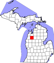 | |
| Villages | ||
| Charter township | ||
| General law townships | ||
| CDPs | ||
| Other unincorporated communities | ||
This article is issued from
Wikipedia.
The text is licensed under Creative Commons - Attribution - Sharealike.
Additional terms may apply for the media files.