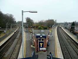
Kidsgrove railway station
| Kidsgrove | |
|---|---|
 | |
| Location | |
| Place | Kidsgrove |
| Local authority | Borough of Newcastle-under-Lyme |
| Grid reference | SJ837543 |
| Operations | |
| Station code | KDG |
| Managed by | East Midlands Trains |
| Number of platforms | 4 |
| DfT category | E |
|
Live arrivals/departures, station information and onward connections from National Rail Enquiries | |
| Annual rail passenger usage* | |
| 2012/13 |
|
| 2013/14 |
|
| 2014/15 |
|
| 2015/16 |
|
| 2016/17 |
|
| History | |
| 9 October 1848 | Opened as Harecastle[1] |
| 2 October 1944 | renamed Kidsgrove Central[1] |
| 18 April 1966 | renamed Kidsgrove[1] |
| National Rail – UK railway stations | |
| * Annual estimated passenger usage based on sales of tickets in stated financial year(s) which end or originate at Kidsgrove from Office of Rail and Road statistics. Methodology may vary year on year. | |
|
| |
Kidsgrove railway station serves the town of Kidsgrove in Staffordshire, England. The station is 7.5 miles (12.07 km) north of Stoke-on-Trent. The station is served by trains on the Crewe to Derby Line which is also a community rail line known as the North Staffordshire line. The station is owned by Network Rail and managed by East Midlands Trains (EMT) train operating company (TOC).
In the year 2009/10 the usage of the station grew by almost 58% to over 100,000 recorded journeys, in addition more than 6,434 passengers used the station to change trains. The increase in usage (followed by a similar increase for 2010/11) has been attributed to improved timetable in December 2008 (specifically the introduction of London Midland's Desiro service to London Euston via Tamworth).[2]
History
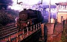
The present station was opened 9 October 1848 by the North Staffordshire Railway as Harecastle and was during the early years of the North Staffordshire era variously called Harecastle Junction, Kidsgrove Junction. Kidsgrove Junction, Harecastle before settling upon Harecastle in 1875.[1] Between 1885/6 and 1923/4 it was called Harecastle for Kidsgrove.[1] In 1944 it was renamed Kidsgrove.
In British Rail days it was known as Kidsgrove Central when the town had three stations, the other two were Kidsgrove Liverpool Rd and Market Street Halt on the old North Staffordshire Railway's Potteries Loop Line (All three stations were opened by the North Staffordshire Railway). It is situated on the Manchester branch of the West Coast Main Line at the junction where the line from Stoke-on-Trent divides for Crewe and Manchester Piccadilly.
It is just north of the Harecastle Tunnels on the Trent and Mersey Canal and the Harecastle railway tunnel and 1965 railway diversion.
Service pattern
Platform 1
- Hourly Northern service direct to Stoke on Trent[3] (operated by class 323 EMUs)
Platform 2
- Hourly Northern service to Manchester Piccadilly calling at Congleton, Macclesfield, Prestbury, Adlington, Poynton, Bramhall, Cheadle Hulme, Stockport, Heaton Chapel and Levenshulme (operated by class 323 EMUs)
Platform 3
- Hourly East Midlands Trains service to Derby calling at Longport, Stoke on Trent, Longton, Blythe Bridge, Uttoxeter, Tutbury and Hatton and Peartree (at peak times)[4] (operated by class 153 or 156 DMUs)
- Hourly London Northwestern service to London Euston calling at Stoke on Trent, Stone, Stafford, Rugeley Trent Valley, Lichfield Trent Valley, Tamworth, Atherstone, Nuneaton, Rugby and Milton Keynes Central.[5] (operated by class 350 EMUs)
Platform 4
- Hourly East Midlands Trains service to Crewe calling at Alsager (operated by class 153 or 156 DMUs)
- Hourly London Northwestern service to Crewe calling at Alsager (operated by class 350 EMUs)
No services operated by Virgin Trains or CrossCountry call at Kidsgrove, (though 4 Cross Country and 4 Virgin Trains services pass through platforms 1 & 2 each hour)
References
- 1 2 3 4 5 Quick, Michael (2009) [2001]. Railway passenger stations in Great Britain: a chronology (4th ed.). Oxford: Railway and Canal Historical Society. p. 231. ISBN 978-0-901461-57-5. OCLC 612226077.
- ↑ Office of Rail Regulation (2010). "Station usage". Office of Rail Regulation. Retrieved 2010-03-29.
- ↑ Table 84 National Rail timetable, May 2016
- ↑ Table 50 National Rail timetable, May 2016
- ↑ Table 67 National Rail timetable, May 2016
External links
| Wikimedia Commons has media related to Kidsgrove railway station. |
- Train times and station information for Kidsgrove railway station from National Rail
| Preceding station | Following station | |||
|---|---|---|---|---|
| East Midlands Trains | ||||
| London Northwestern Railway London - Crewe | ||||
| Northern Stoke-Manchester | ||||
| Preceding station | Historical railways | Following station | ||
Line open, station closed | North Staffordshire Railway | Line and station closed |
||
Line open, station closed | North Staffordshire Railway | |||
Line and station closed | North Staffordshire Railway Sandbach to Stoke Line |
.svg.png)