Hardy Cemetery
|
Hardy Cemetery Historic Section | |
 | |
  | |
| Location | Bounded by Main St., Kelly St., Cope Ave. and Burlington RR, Hardy, Arkansas |
|---|---|
| Coordinates | 36°19′2″N 91°28′44″W / 36.31722°N 91.47889°WCoordinates: 36°19′2″N 91°28′44″W / 36.31722°N 91.47889°W |
| Area | 1.1 acres (0.45 ha) |
| Built | 1888 |
| MPS | Hardy, Arkansas MPS |
| NRHP reference # | 06000089[1] |
| Added to NRHP | March 2, 2006 |
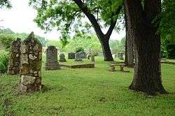
The Hardy Cemetery is the main cemetery of Hardy, Arkansas. It is located on the south side of Main Street, east of Hardy's downtown business district. The cemetery is about 1.6 acres (0.65 ha) in size. When the city of Hardy was laid out in 1883, a 1.1-acre (0.45 ha) parcel of land for the cemetery was donated by one of its founders, Walker Clayton. This was expanded by about 1/2 acre in 1979, with the donation of land by members of the Biggers family. The original portion of the cemetery, where a number of Hardy's founders and later leading citizens are buried, was listed on the National Register of Historic Places in 2006.[2]
See also
References
- ↑ National Park Service (2010-07-09). "National Register Information System". National Register of Historic Places. National Park Service.
- ↑ "NRHP nomination for Hardy Cemetery Historic Section" (PDF). Arkansas Preservation. Retrieved 2015-01-01.
| Topics | |
|---|---|
| Lists by states |
|
| Lists by insular areas | |
| Lists by associated states | |
| Other areas | |
| |
This article is issued from
Wikipedia.
The text is licensed under Creative Commons - Attribution - Sharealike.
Additional terms may apply for the media files.