Harder, Washington
| Harder, Washington | |
|---|---|
| Unincorporated community | |
 Harder  Harder | |
| Coordinates: 46°39′43″N 118°29′20″W / 46.66194°N 118.48889°WCoordinates: 46°39′43″N 118°29′20″W / 46.66194°N 118.48889°W | |
| Country | United States |
| State | Washington |
| County | Franklin |
| Elevation | 922 ft (281 m) |
| Time zone | UTC-8 (Pacific (PST)) |
| • Summer (DST) | UTC-7 (PDT) |
| Area code(s) | 509 |
| GNIS feature ID | 1511023[1] |
Harder is an unincorporated community in Franklin County, Washington, United States[1]
Notes
Municipalities and communities of Franklin County, Washington, United States | ||
|---|---|---|
| Cities | 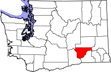 | |
| CDPs | ||
| Unincorporated communities | ||
| Ghost towns | ||
This article is issued from
Wikipedia.
The text is licensed under Creative Commons - Attribution - Sharealike.
Additional terms may apply for the media files.