Road 77 (Iran)
| |
|---|---|
| جاده 77 | |
| Caspian to Tehran Road | |
.jpg) | |
| Route information | |
| Length | 200 km (100 mi) |
| Major junctions | |
| From |
Tehran, Tehran Province |
|
| |
| To |
Mahmood Abad, Mazandaran Province |
| Location | |
| Provinces | Tehran, Mazandaran |
| Major cities |
Rudehen, Tehran Province Amol, Mazandaran Province |
| Highway system | |
| Freeways | |
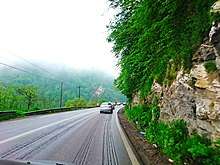
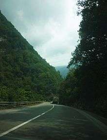
Road 77, also known as the Haraz Road, is one of the most important roads from Tehran to the northern mountains of Iran, and the Iranian coast on the southern Caspian Sea. is an important road for people of Iran.
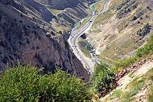
Along the road landscapes, Plain, Mountain, Historical tourism. Waterfall and village.
Route
The road's route travels through Tehran Province and Mazandaran Province. It crosses the Alborz mountain range and then descends northwards down the Haraz River Valley. The road is the shortest route from Tehran to the north ( 180 km) and in recent years some parts of the road has been widened and the safety has been improved. It passes through the towns of Amol and Rudehen.
Features
Haraz Road is the nearest road to Mount Damavand, the highest peak in Iran and Middle East. Lar Dam, Lar National Park, which Mount Damavand is within, is easily accessible from Road 77.
Central Alborz mountain range map
| Map of central Alborz | Peaks: | 1 Alam-Kuh |
|---|---|---|
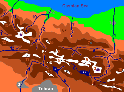 −25 to 500 m (−82 to 1,640 ft) 500 to 1,500 m (1,600 to 4,900 ft) 1,500 to 2,500 m (4,900 to 8,200 ft) 2,500 to 3,500 m (8,200 to 11,500 ft) 3,500 to 4,500 m (11,500 to 14,800 ft) 4,500 to 5,671 m (14,764 to 18,606 ft) |
2 Azad Kuh | 3 Damavand |
| 4 Do Berar | 5 Do Khaharan | |
| 6 Ghal'eh Gardan | 7 Gorg | |
| 8 Kholeno | 9 Mehr Chal | |
| 10 Mishineh Marg | 11 Naz | |
| 12 Shah Alborz | 13 Sialan | |
| 14 Tochal | 15 Varavašt | |
| Rivers: | 0 | |
| 1 Alamut | 2 Chalus | |
| 3 Do Hezar | 4 Haraz | |
| 5 Jajrood | 6 Karaj | |
| 7 Kojoor | 8 Lar | |
| 9 Noor | 10 Sardab | |
| 11 Seh Hazar | 12 Shahrood | |
| Cities: | 1 Amol | |
| 2 Chalus | 3 Karaj | |
| Other: | D Dizin | |
| E Emamzadeh Hashem | K Kandovan Tunnel | |
| * Latyan Dam | ** Lar Dam |
See also
- Road 59 − Karaj-Chaloos Road — another main Tehran−Caspian route.
- Alborz (Elburz) mountain range topics
| Freeways |
| |||||
|---|---|---|---|---|---|---|
| First-Class Roads | ||||||