Hao (French Polynesia)
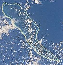 NASA picture of Hao Atoll | |
 Hao | |
| Geography | |
|---|---|
| Location | Pacific Ocean |
| Coordinates | 18°4′31″S 140°56′43″W / 18.07528°S 140.94528°W |
| Archipelago | Tuamotus |
| Area |
720 km2 (280 sq mi) (lagoon) 35 km2 (14 sq mi) (above water) |
| Length | 50 km (31 mi) |
| Width | 14 km (8.7 mi) |
| Highest elevation | 3 m (10 ft) |
| Administration | |
|
France | |
| Overseas collectivity | French Polynesia |
| Administrative subdivision | Tuamotus |
| Commune | Hao |
| Largest settlement | Otepa |
| Demographics | |
| Population | 1066[1] (2012) |
| Hao | |
|---|---|
| Commune | |
 Flag of Hao | |
 | |
| Coordinates: 18°04′31″S 140°56′43″W / 18.0753°S 140.9453°WCoordinates: 18°04′31″S 140°56′43″W / 18.0753°S 140.9453°W | |
| Country | France |
| Overseas collectivity | French Polynesia |
| Government | |
| • Mayor (2008–2014) | Suzanne Merehau |
| Area | 98 km2 (38 sq mi) |
| Population (2016)1 | 1,630 |
| • Density | 17/km2 (43/sq mi) |
| INSEE/Postal code | 98720 /98767 |
| Elevation | 0–3 m (0.0–9.8 ft) |
| 1 Population without double counting: residents of multiple communes (e.g., students and military personnel) only counted once. | |
Hao, or Haorangi,[2] is a large coral atoll in the central part of the Tuamotu Archipelago. It has c. 1000 people living on 35 km². It was used to house the military support base for the nuclear tests on Mururoa. Because of its shape, French explorer Louis Antoine de Bougainville named it "Île de la Harpe" (Harp Island).
Geography
Hao is 920 km east of Tahiti. It is 50 km long and 14 km wide. The lagoon is the fourth largest atoll in French Polynesia (after Rangiroa, Fakarava, and Makemo) and has only one navigable passage, at Kaki, on the north end of the atoll where strong currents prevail up to 20 knots with bores. The lagoon covers an area of 720 km².
The climate is maritime, with temperatures oscillating between 23 and 32 °C throughout the year.
The chief town is the village of Otepa, where the main economic activity is the cultivation of pearls.

History
The first recorded European arriving on Hao was Pedro Fernández de Quirós on 10 February 1606. He named it Conversion de San Pablo.[3] He was followed by José Andía y Varela in 1774.
Because of its shape, French explorer Louis Antoine de Bougainville named it "Île de la Harpe" (Harp Island). In some maps it also appears as Bow Island.[2][4]
Hao was the first atoll of the Tuamotus that Russian explorer Fabian Gottlieb von Bellingshausen visited in 1820 on the ships Vostok and Mirni.
In the late-1980s, two French intelligence (DGSE) operatives were briefly confined to the military base on the island after France obtained their release from a New Zealand prison for sinking the Greenpeace ship Rainbow Warrior. Their earlier-than-agreed-upon repatriation from the island by the French government became a diplomatic incident between New Zealand and France.
Hao's military airfield, now known as Hao Airport, was transferred to the civilian authorities in 2000. This airport (IATA: HOI, ICAO: NTTO) serves many of the smaller eastern Tuamotus, whose landing strips are too short to land aircraft large enough to make the flight to Tahiti.
The economic future of the atoll remains in question: the military base, which was the support base for nuclear testing on the nearby Mururoa atoll, was permanently shut down in 2002, along with its many support facilities, including the electrical and desalinization plants and the hospital. The livelihood of many of the atoll's inhabitants was directly tied to the military base.
Administration
Hao forms the commune of Hao (Main village: Otepa), which also includes Ahunui (uninhabited), Nengonengo, Manuhangi (uninhabited) and Paraoa (uninhabited). As of the 2016 census, the atoll's total population was 1275.
The commune of Hao is associated with the commune of Amanu and the commune of Hereheretue.
Demographics
see Administrative divisions of French Polynesia for demographics information.
Transport
Hao Airport (IATA: HOI, ICAO: NTTO) is in the island's north. It is used as a base by Air Tahiti, the domestic airline of French Polynesia.
Related article
References
- ↑ "Population". Institut de la statistique de la Polynésie française. Retrieved 26 September 2014.
- 1 2 Young, J.L. (1899). "Names of the Paumotu Islands, with the old names so far as they are known". Journal of the Polynesian Society. 8 (4): 264–268. Retrieved 7 January 2015.
- ↑ Kelly, Celsus, O.F.M. La Austrialia del Espiritu Santo. The Journal of Fray Martín de Munilla O.F.M. and other documents relating to the Voyage of Pedro Fernández de Quirós to the South Sea (1605-1606) and the Franciscan Missionary Plan (1617-1627) Cambridge, 1966, p.39,62.
- ↑ Salmond, Anne (2010). Aphrodite's Island. Berkeley: University of California Press. p. 93. ISBN 9780520261143.
External links
| Wikimedia Commons has media related to Hao. |
- History of Hao Atoll
- Classification of the French Polynesian atolls by Salvat (1985)
- Atoll list (in French)
- Oceandots
- Iero
- Andía y Varela
- Bellingshausen
Tuamotus Gambiers | Islands/Atolls | ||
|---|---|---|---|
| Island groups | |||