Hambach surface mine
The Tagebau Hambach is a large open-pit coal mine (German: Tagebau) in Niederzier and Elsdorf, North-Rhine Westphalia, Germany. It is operated by RWE and used for mining lignite.
The mine is on the site of the ancient Hambach Forest which was purchased by RWE in 1978. They then cut most of it down and cleared it to mine. Only 10% of the forest area remains. RWE plans to clear half of the remaining area of the forest between around 2018 and 2020; this plan was met with massive protests in autumn 2018, and was temporarally stopped in October 2018 by the Oberverwaltungsgericht für das Land Nordrhein-Westfalen (highest state court of North Rhine-Westphalia).[1][2][3]
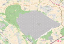
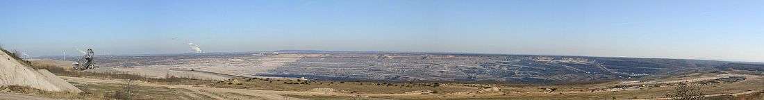
Begun in 1978, the mine's operation area currently (as of end of 2017) has a size of 43,8 km², with the total area designated for mining having a size of 85 km².[4] It is the deepest open pit mine with respect to sea level: the bottom of the pit is 299 metres (981 ft) below sea level,[5] the deepest artificially made point on the Earth's surface.
Data
The open pit operator RWE, then known as Rheinbraun, initiated the permitting process for open pit mining in 1974 and was able to commence operations in 1978. The first excavator began its work on 15 October 1978. This was accompanied by the resettlement of local villages and towns and the largest forest area in the region, the Hambacher Forst, was largely cleared. On January 17, 1984, the first brown coal was mined.
Hambach is the largest open pit mine in Germany with an area of 3,389 hectares (as of 2007) with an approved maximum size of 8500 hectares. About 40 million tons of lignite are produced annually in this mine. It has recently been estimated that 1772 million tons of lignite are still available for mining. The lignite was created from extensive forests and bogs, which developed in the Lower Rhine Bay between 30 to 5 million years ago. The geology of the Lower Rhine Bay is characterized by long-lasting subsidence movements in the last 30 million years, which led to the deposition of up to 1300 m thick sediment layers through the North Sea and many rivers, which today consist of lignite seams up to 100 m thick.
At 299 m below seal level, the deepest point of the Hambach open-pit mine forms the deepest artificial depression in North Rhine-Westphalia.[5]
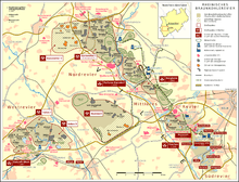
The opencast mine annually produces a spoil amount of 250 to 300 million m³. The ratio of overburden to coal is 6.2:1. The extracted lignite is transported via the Hambachbahn to Bergheim - Auenheim and from there transported via the north-south railway to the power stations Niederaussem, Neurath, Frimmersdorf and Goldenberg near Hürth-Knapsack. The overburden was until 16 April 2009 partially transported by conveyor belt to the Bergheim mine, which has run out of coal and therefore been refilled and recultivated. The visible mark of the open pit is the Sophienhöhe spoil tip, which is considered to be the largest man-made hill, towering over the flat landscape by 200 metres.
From 2013, the open pit area is to be extended southeast. For this, the villages Morschenich and Manheim must be relocated. The A4 motorway and the Hambachbahn, via which the lignite is transported to the power stations, were laid around three kilometres to the south parallel to the Cologne-Aachen railway line. In addition, a small piece of the federal highway 477 was moved east.[6]
Backfilling the residual hole
The open pit mine was put into operation in 1978. Every year about 0.3 cubic kilometres are moved, so that coal and soil with a volume of about 18.6 km³ will be mined by the time the coal runs out in 2040. By April 2009, the overburden, which was hitherto incurred in Hambach is now transported by conveyor belt in the now exhausted Bergheim mine to fill this in again. Now it is tilted exclusively on the western edge of the opencast mine and on the Sophienhöhe. Due to the accumulation of about 1 km³ of material at the Sophienhöhe and the extracted coal, a residual hole is created, which is to be filled up with water after completion of the mining activities.
A lake with an area of 4200 ha, a depth of up to 400 m and a volume of 3.6 billion m³ is planned. Size and volume depend on whether the west-located open pit Inden after its decarburization as well as the mine Bergheim filled with material from the open pit Hambach or left open. Lake Hambach would then be the deepest and (in terms of volume) after Lake Constance the second largest lake in Germany. How to fill the opencast mine is still controversial. Some voices suggest taking water from the Rur and / or the Erft or even filling the open pit with a pipeline of Rhine water. However this happens, the filling of the open pit mine is expected to take several decades. Thus, a completion of this artificial water is not expected before the year 2100.
In addition to the complete flooding is also possible to build a pumped storage power plant. A patent from 1995 states that such a pumped storage plant in the Hambach opencast mine can be realized and can provide a multiple of the pumped storage capacity currently available in Germany.[7] The increased use of renewable energy makes this option more important and is being followed with interest by the Mining Authority.[8]
Criticism and protests
Since around 2012, an area within the remaining part of the Hambach Forest has been occupied by environmentalists to prevent its planned destruction by RWE.
The occupation involves a settlement with around two dozen tree houses and numerous road barricades. The barricades were erected to prevent mining company and police vehicles from entering.[9]
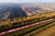
In November 2017 environmentalists entered the mine and temporarily halted operations. They were met with police using horses and pepper spray.
In 2004 Greenpeace activists demonstrated against climate damage in the Hambach mine due to power generation using lignite. They flew over the open pit with a hot air balloon, occupied an excavator for several days and painted it partly pink. On May 13, 2009, the joint action of the local action group of citizens' initiatives against the relocation of the A4 and Friends of the Earth Germany (BUND) failed before the Federal Administrative Court. The plaintiffs tried to stop the relocation of the A4, which was deemed necessary for the planned extension of the open pit mine and justified this, inter alia, with feared noise pollution as well as the possible threat to the protected Bechstein bat and other species. In 2009, the construction of the new section of motorway began, in September 2014, it was opened to traffic.
Since 2008, there have increasing complaints about possible damage to the hill in the Elsdorf-Heppendorf area; since the burden of proof lies with the complainants, it is difficult to prove the mining operator guilty. The newly formed brown coal committee therefore decided on April 16, 2010, to set up the Bergschaden Braunkohle NRW reclamation service for damage victims in the Rhenish lignite mining area. The former chairman of the Higher Regional Court Hamm Gero Debusmann was appointed chairman of the recourse office. He is already chairman of the conciliation body mining damage in the coal industry. He can be contacted if attempts at reconciliation with RWE Power remain unsatisfactory. The procedure is free of charge for the applicant.[10]
In November 2012 and March 2013, the police cleared tent and hut camps of mining opponents in the remaining Hambacher Forst. In 2012, a squatter had to be fetched from a six-metre deep tunnel and the following year two activists were roped off a tree platform. Later, a new camp was built at another location in the Hambacher forest.
Coordinates: 50°54′39″N 6°30′10″E / 50.91083°N 6.50278°E
| Wikimedia Commons has media related to Tagebau Hambach. |
See also
- Tagebau Garzweiler
- Morschenich
- Manheim (Kerpen)
- Hambach (Niederzier)
References
- ↑ "Münster: Gericht stoppt vorläufig Rodung im Hambacher Forst". Spiegel Online (in German). 2018-10-05. Retrieved 2018-10-05.
- ↑ tagesschau.de (2018-10-05). "OVG Münster stoppt vorerst Rodung im Hambacher Forst". tagesschau.de (in German). Retrieved 2018-10-05.
- ↑ "Gericht verfügt vorläufigen Rodungsstopp". zeit.de (in German). 2018-10-05. Retrieved 2018-10-05.
- ↑
- 1 2 "Nordrhein-Westfalen in Zahlen" (PDF) (in German). Bezirksregierung Köln, Abteilung Geobasis NRW. 2013-02-05. Retrieved 2016-02-05.
- ↑ Jörg Fehres: Die Unternehmensflurbereinigung – Beispiel für ein erfolgreiches Instrument zur Umsetzung von Infrastrukturmaßnahmen. In: zfv Zeitschrift für Geodäsie, Geoinformation und Landmanagement, Heft 4/2010, S. 275–279, Augsburg 2010, ISSN 1618-8950
- ↑ Pumpspeicherwerk – Patent DE 19513817 B4, accessed 2014-06-01
- ↑ Tagebau Hambach: Saubere Energie aus dem Kohleloch, Kölner Stadtanzeiger, accessed 2014-06-01
- ↑ "Special Report from the Occupied Forest: Meet Activists Fighting Europe's Largest Open-Pit Coal Mine".
- ↑ Braunkohlenausschuss beschließt Einrichtung einer Anrufungsstelle Bergschaden Braunkohle NRW, Pressemeldung 036/2010 der Bezirksregierung Köln, 2010-04-16 (PDF; 28 kB), accessed 2010-04-25
- RWE. "Hambach mine site". www.group.rwe. Retrieved 2018-10-02.
External links
| Divisions and subsidiaries |
|  | ||||
|---|---|---|---|---|---|---|
| Joint ventures and shareholdings |
| |||||
| Places and facilities | ||||||
| People | ||||||
| Other | ||||||
| ||||||