Halsanaustan
| Halsanaustan Halsa | |
|---|---|
| Village | |
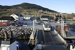 View of Halsa, near the ferry | |
 Halsanaustan Location in Møre og Romsdal  Halsanaustan Halsanaustan (Norway) | |
| Coordinates: 63°04′18″N 08°15′03″E / 63.07167°N 8.25083°ECoordinates: 63°04′18″N 08°15′03″E / 63.07167°N 8.25083°E | |
| Country | Norway |
| Region | Western Norway |
| County | Møre og Romsdal |
| District | Nordmøre |
| Municipality | Halsa Municipality |
| Elevation[1] | 47 m (154 ft) |
| Time zone | UTC+01:00 (CET) |
| • Summer (DST) | UTC+02:00 (CEST) |
| Post Code | 6680 Halsanaustan |
Halsanaustan or just Halsa is a village in Halsa Municipality in Møre og Romsdal county, Norway. The village is located along European route E39 at the junction of County Road 350 on an isthmus of a small peninsula between the Halsafjorden and Skålvik Fjord, about 10 kilometres (6.2 mi) southwest of the municipal center of Liabøen. There is a ferry from Halsanausta to Kanestraum in Tingvoll Municipality, across the Halsafjorden. Halsa Church is located in this village.
References
This article is issued from
Wikipedia.
The text is licensed under Creative Commons - Attribution - Sharealike.
Additional terms may apply for the media files.