Halali Airport
| Halali Airport | |||||||||||||||
|---|---|---|---|---|---|---|---|---|---|---|---|---|---|---|---|
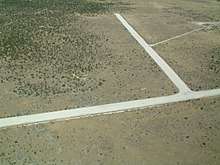 aerial view of Halali Airport in 2002 | |||||||||||||||
| Summary | |||||||||||||||
| Airport type | Public | ||||||||||||||
| Serves | Halali | ||||||||||||||
| Elevation AMSL | 3,640 ft / 1,109 m | ||||||||||||||
| Coordinates | 19°01′50″S 16°27′30″E / 19.03056°S 16.45833°ECoordinates: 19°01′50″S 16°27′30″E / 19.03056°S 16.45833°E | ||||||||||||||
| Map | |||||||||||||||
 HAL Location of the airport in Namibia | |||||||||||||||
| Runways | |||||||||||||||
| |||||||||||||||
Halali Airport (IATA: HAL, ICAO: FYHI) is an airport serving the resort of Halali, in the Oshikoto Region of Namibia. The resort is near some of the waterholes of the Etosha National Park, and has elevated viewing platforms for observing native wildlife like elephants, rhinoceros, and leopards.
See also

- List of airports in Namibia
- Transport in Namibia
References
- ↑ Google Maps - Halali
- ↑ Airport information for HAL at Great Circle Mapper.
External links
This article is issued from
Wikipedia.
The text is licensed under Creative Commons - Attribution - Sharealike.
Additional terms may apply for the media files.