Hajdúszoboszló
| Hajdúszoboszló | ||
|---|---|---|
| Town | ||
| ||
| Nickname(s): "The sunniest city in Hungary" and "Mecca for rheumatism" | ||
 Hajdúszoboszló | ||
| Coordinates: 47°26′37.1″N 21°23′22.28″E / 47.443639°N 21.3895222°E | ||
| Country |
| |
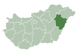
| County | Hajdú-Bihar | |
| District | Hajdúszoboszló | |
| Government | ||
| • Mayor | László Sóvágó dr. | |
| Area | ||
| • Total | 238.7 km2 (92.2 sq mi) | |
| Population (2017) | ||
| • Total | 23,781[1] | |
| Time zone | UTC1 (CET) | |
| • Summer (DST) | UTC+2 (CEST) | |
| Postal code | 4200 | |
| Area code | (+36) 52 | |
| Website |
hajduszoboszlo | |

Hajdúszoboszló (Hungarian pronunciation: [ˈhɒjduːsobosloː]) is a town in Hajdú-Bihar county, Hungary, 19 kilometres (12 miles) southwest of county seat Debrecen. It is the third largest town in Hajdú-Bihar county.
Location
The town is located in the northeastern part of the Great Hungarian Plain. Three regions meet near the town: the Hajdúhát ridge to the north-north-east, the Hortobágy National Park (Puszta) to the north-north-west, and the Great Sárrét and Berettyó region to the south. Szoboszló lies at an altitude of scarcely 100 to 110 metres (328–361 ft) above sea level and slopes slightly towards Hortobágy.
This is a landscape "where earth and sky meet", but not a monotonous plain, even for travellers accustomed to romantic mountains, since here and there the landscape is enlivened by the backwaters of the Tisza River with patches of reed, thousands of wild fowl, and inviting groves. The surroundings are the renowned puszta, the "glorious plain".
History
From historical data and archaeological finds, this part of the Great Plain was inhabited as far back as the Great Migrations. Because of the natural resources and the convergence of trade routes, Huns, Vandals, Gepids, Goths, and Avars frequently alternated with one another in this area. Early in the reign of the Árpád Dynasty, the area was inhabited by populous communities. The first written mention of Szoboszló dates back to 1075, when King Géza I donated half of Szoboszló's royal duty taxes to the new abbacy to be established at Garamszentbenedek.
With an ornate deed of gift dated 2 September 1606, István Bocskai, Prince of Transylvania, provided smallholdings for 700 Hajdú (Heyduck) cavalrymen at the site of Szoboszló, which had been destroyed by the Crimean Tartars. Henceforth the prefix Hajdú was attached to the settlement's previous Slavonic name, though the compound form - Hajdúszoboszló - only became widespread in the 19th century. The town led the customary, toilsome life of the small agricultural, stock-breeding towns of Hajdú County until well into the 20th century.
An upswing began on 26 October 1925 with the discovery of the thermal spring in the course of drilling for oil and gas. The medicinal water, tinged with natural iodine, led to the town's development into a resort spa, while agriculture retained its significant role even after the discovery of the gas field.
Population
- 1870 - 12,269
- 1920 - 17,722
- 1970 - 22,000
- 2002 - 23,874
- 2005 - 23,827
- 2009 - 23,295

Spa complex
The water park includes water slides, an olympic-sized swimming pool, and a wave pool, while the spa features graded thermal pools, including a tepidarium and jacuzzi-type hot baths.
Official website: http://hajduszoboszlo.hu/en/
Sister cities
Hajdúszoboszló is twinned with:


References
- Notes
- ↑ Hajdúszoboszló, KSH
- ↑ "Oficiálne stránky mesta Kežmarok". kezmarok.sk. Archived from the original on 1 March 2010. Retrieved 8 February 2010.
External links
| Wikimedia Commons has media related to Hajdúszoboszló. |
| Wikivoyage has a travel guide for Hajúszoboszló. |
- Official website in Hungarian, English, German, Russian, Polish, Slovakian, Romanian and Czech
- hajduszoboszlonoclegi.pl accommodation in Hajduszoboszlo
- vendegzona.hu accommodation in Hajduszoboszlo
- All accommodations in Hajdúszoboszló hajduszoboszlo-szallas.lap.hu
- Great accommodation offers in Hajdúszoboszló www.szallasmagyarorszag.hu
- Hajdúszoboszló at funiq.hu
| Towns (2) |
| |
|---|---|---|
| Villages (3) | ||
| City with county rights |
|   |
|---|---|---|
| Towns | ||
| Large villages | ||
| Villages |
| |
| Other topics |
| |