Haines Junction Airport
| Haines Junction Airport | |||||||||||
|---|---|---|---|---|---|---|---|---|---|---|---|
 | |||||||||||
| Summary | |||||||||||
| Airport type | Public | ||||||||||
| Operator | Government of Yukon | ||||||||||
| Location | Haines Junction, Yukon, Canada | ||||||||||
| Time zone | PST (UTC−08:00) | ||||||||||
| • Summer (DST) | PDT (UTC−07:00) | ||||||||||
| Elevation AMSL | 2,150 ft / 655 m | ||||||||||
| Coordinates | 60°47′22″N 137°32′43″W / 60.78944°N 137.54528°WCoordinates: 60°47′22″N 137°32′43″W / 60.78944°N 137.54528°W | ||||||||||
| Map | |||||||||||
 CYHT Location in Yukon | |||||||||||
| Runways | |||||||||||
| |||||||||||
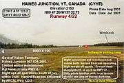
Haines Junction Airport (IATA: YHT, ICAO: CYHT) is located 2 nautical miles (3.7 km; 2.3 mi) northwest of Haines Junction, Yukon, Canada. The airport has no scheduled airline service and is served by one fixed wing charter and two helicopter operators. Haines Junction is the gateway to Kluane National Park and Reserve. The airport is also the headquarters for the Yukon Governments Community and Transportation Services Airport Division.
Gallery
Haines Junction Airport
Haines Junction airport windsock

Haines Junction airport taxiway

Haines Junction airport runway
Haines Junction airport terminal

Haines Junction airport terminal and ramp parking
References
- ↑ Canada Flight Supplement. Effective 0901Z 19 July 2018 to 0901Z 13 September 2018.
- ↑ Synoptic/Metstat Station Information
External links
- Page about this airport on COPA's Places to Fly airport directory
| By name | |
|---|---|
| By location indicator | |
| By province/territory | |
| By area | |
| National Airports System | |
| Related | |
| |
This article is issued from
Wikipedia.
The text is licensed under Creative Commons - Attribution - Sharealike.
Additional terms may apply for the media files.