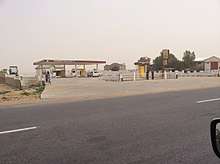
Hadejia
| Hadejia | |
|---|---|
| LGA and town | |
| Motto(s): Majestic City of Stallion | |
 Hadejia | |
| Coordinates: 12°27′N 10°2′E / 12.450°N 10.033°E | |
| Country |
|
| State | Jigawa State |
| Time zone | UTC+1 (WAT) |
Hadejia (also Hadeja, previously Biram) is a Hausa town in eastern Jigawa State, northern Nigeria. The population was approximately 105,628 in 2006.[1] The people of Hadejia are largely Muslim, although some follow indigenous belief systems. The town lies to the north of the Hadejia River, and is upstream from the Hadejia-Nguru wetlands, an internationally important ecological and sensitive zone.[2]
Hadejia was once known as Biram, and is referred to as one of the "seven true Hausa states" (Hausa Bakwai),[3] because it was ruled by the descendants of the Hausa mythological figure Bayajidda and his second wife, Daurama.[4] By 1810, during the Fulani War, the Hausa rulers of the Hausa Bakwai had all been overcome by the Fulani.[5] Hadejia had been transformed into an Emirate two years earlier, in 1808. In 1906 Hadejia resisted British occupation, under the then Emir (Muhammadu Mai-Shahada).[1] Hadejia was absorbed into Jigawa State in 1991. Hadejia is a center for rice and wheat farming and is strong in poultry, fish and animal farming.

Binyaminu Usman Polytechnic is located at Hadejia.[6]
The Duwai language is spoken in Hadejia LGA.[7]
References
- 1 2 "Hadejia". Encyclopædia Britannica. Encyclopædia Britannica, Inc. Retrieved 2006-12-22.
- ↑ Muhammad J. Chiroma; Yahaya D. Kazaure; Yahya B. Karaye; Abba J. Gashua. "Water Management Issues in the Hadejia-Jama'are-Komadugu-Yobe Basin: DFID-JWL and Stakeholders Experience in Information Sharing, Reaching Consensus and Physical Interventions" (PDF). International Water Management Institute. Retrieved 2009-10-03.
- ↑ "Daura". Encyclopædia Britannica. Encyclopædia Britannica, Inc. Retrieved 2006-12-21.
- ↑ Dierk Lange. "Oral version of the Bayajidda legend" (PDF). Ancient Kingdoms of West Africa. Retrieved 2006-12-21.
- ↑ Johnston, H. A. S (1967). "The Consolidation of the Empire". The Fulani Empire of Sokoto. Amana Online. Retrieved 2007-01-21.
- ↑ "About Us". Retrieved 2010-03-17.
- ↑ "Duwai". Ethnologue. Retrieved 2014-05-25.
External links
Coordinates: 12°27′N 10°02′E / 12.45°N 10.04°E
State capital: Dutse | ||
| Local Government Areas | 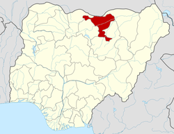 | |