Haddington Hill
| Haddington Hill | |
|---|---|
 Wendover Woods near the summit of Haddington Hill | |
| Highest point | |
| Elevation | 267 m (876 ft) |
| Prominence | 180 m (590 ft) |
| Parent peak | Cleeve Hill |
| Listing | Marilyn, County Top |
| Coordinates | 51°46′18″N 0°42′42″W / 51.77171°N 0.71154°WCoordinates: 51°46′18″N 0°42′42″W / 51.77171°N 0.71154°W |
| Geography | |
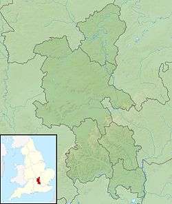 Haddington Hill Haddington Hill in Buckinghamshire | |
| Location | Chiltern Hills, England |
| OS grid | SP890089 |
| Topo map | OS Landranger 165 |
| Listed summits of Haddington Hill | ||||
| Name | Grid ref | Height | Status | |
|---|---|---|---|---|
| Pavis Wood | SP914091 | 244 m (801 ft) | County Top | |
Haddington Hill (also called Wendover Hill[1]) is a hill in The Chilterns, and the highest point in the English county of Buckinghamshire. On the north-eastern flank is Coombe Hill, not to be confused with another Coombe Hill 4 kilometres to the south-west.
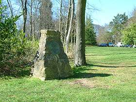
Haddington Hill is owned by the Forestry Commission, whose Wendover Woods cover much of the hill. Many tracks run through the forest, and a car park is located near the summit among the trees: the flat summit means the precise location of the highest point is difficult to determine with certainty. However, in the woods to the east of the car park there are a series of large stones bearing the inscription 'The Chiltern Summit'. The stones are surrounded by trees.
Ascents
The peak is accessible by road, with a car park near the stone. It is also possible to climb on foot.
Pavis Wood
The highest point of Hertfordshire, at 244 metres (801 ft), is on the eastern ridge of this hill, on the boundary with Buckinghamshire.
See also
References
- ↑ The Hardys – The UK’s High Points at www.thehardys.org. Accessed on 15 Mar 2013.