Wendover Woods
| Wendover Woods | |
|---|---|
 Wendover Woods near the summit of Haddington Hill | |
| Highest point | |
| Elevation | 160–267 m (525–876 ft) |
| Geography | |
| Location | Chiltern Hills, England |
| OS grid | SP890089 |
| Topo map | OS Landranger 165 |
Wendover Woods is an area of woodland on the north edge of the Chiltern Hills in England. Named after the nearby town of Wendover, the woods are owned by the Forestry Commission.
Covering 325 ha (800 acres), the woods are a mixture of coniferous and broadleaved trees. There are several signed walks for recreation, as well as bridleways, picnic and barbecue areas and a children's playground. A Go Ape treetop adventure course opened in 2008.
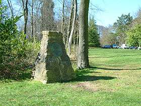
There are views of the countryside in the Aylesbury Vale to the north, and a stone monument marking the highest point of the Chilterns which lies within the woods on Haddington Hill.
The Aston Hill Mountain Bike Area is at the edge of the woods.
External links
Coordinates: 51°46′18″N 0°42′42″W / 51.77171°N 0.71154°W
This article is issued from
Wikipedia.
The text is licensed under Creative Commons - Attribution - Sharealike.
Additional terms may apply for the media files.