Hachita, New Mexico
| Hachita, New Mexico | |
|---|---|
| Census-designated place | |
 Hachita  Hachita | |
| Coordinates: 31°55′05″N 108°19′13″W / 31.91806°N 108.32028°WCoordinates: 31°55′05″N 108°19′13″W / 31.91806°N 108.32028°W | |
| Country | United States |
| State | New Mexico |
| County | Grant |
| Area[1] | |
| • Total | 4.072 sq mi (10.55 km2) |
| • Land | 4.072 sq mi (10.55 km2) |
| • Water | 0 sq mi (0 km2) |
| Elevation | 4,521 ft (1,378 m) |
| Population (2010)[2] | |
| • Total | 49 |
| • Density | 12/sq mi (4.6/km2) |
| Time zone | UTC-7 (Mountain (MST)) |
| • Summer (DST) | UTC-6 (MDT) |
| ZIP code | 88040 |
| Area code(s) | 575 |
| GNIS feature ID | 920609[3] |
Hachita is a census-designated place in Grant County, New Mexico, United States. Its population was 49 as of the 2010 census. Hachita has a post office with ZIP code 88040.[4][5] New Mexico State Road 9, New Mexico State Road 81, and New Mexico State Road 146 pass through the community. Hachita is not to be confused with Old Hachita, which is a ghost town several miles west of town.
References
- ↑ "US Gazetteer files: 2010, 2000, and 1990". United States Census Bureau. 2011-02-12. Retrieved 2011-04-23.
- ↑ "American FactFinder". United States Census Bureau. Retrieved 2011-05-14.
- ↑ "Hachita". Geographic Names Information System. United States Geological Survey.
- ↑ United States Postal Service (2012). "USPS - Look Up a ZIP Code". Retrieved 2012-02-15.
- ↑ "Postmaster Finder - Post Offices by ZIP Code". United States Postal Service. Retrieved August 7, 2013.
Municipalities and communities of Grant County, New Mexico, United States | ||
|---|---|---|
| City | 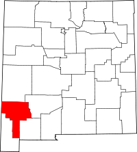 | |
| Towns | ||
| Village | ||
| CDPs | ||
| Other unincorporated communities | ||
| Ghost towns | ||
This article is issued from
Wikipedia.
The text is licensed under Creative Commons - Attribution - Sharealike.
Additional terms may apply for the media files.