Cobre, New Mexico
| Cobre, New Mexico | |
|---|---|
| Census-designated place | |
 Cobre  Cobre | |
| Coordinates: 32°46′50″N 108°06′43″W / 32.78056°N 108.11194°WCoordinates: 32°46′50″N 108°06′43″W / 32.78056°N 108.11194°W | |
| Country | United States |
| State | New Mexico |
| County | Grant |
| Area[1] | |
| • Total | 0.067 sq mi (0.17 km2) |
| • Land | 0.067 sq mi (0.17 km2) |
| • Water | 0 sq mi (0 km2) |
| Elevation | 5,994 ft (1,827 m) |
| Population (2010)[1] | |
| • Total | 39 |
| • Density | 580/sq mi (220/km2) |
| Time zone | UTC-7 (Mountain (MST)) |
| • Summer (DST) | UTC-6 (MDT) |
| Area code(s) | 575 |
| GNIS feature ID | 905228[2] |
Cobre is a census-designated place in Grant County, New Mexico, United States. Its population was 39 as of the 2010 census.[1] New Mexico State Road 356 passes through the community.
Geography
Cobre is located at 32°46′50″N 108°06′38″W / 32.780418°N 108.110631°W. According to the U.S. Census Bureau, the community has an area of 0.067 square miles (0.17 km2), all of it land.[1]
References
- 1 2 3 4 "2010 Census Gazetteer Files - Places: New Mexico". U.S. Census Bureau. Archived from the original on July 14, 2014. Retrieved August 22, 2014.
- ↑ "Cobre". Geographic Names Information System. United States Geological Survey.
Municipalities and communities of Grant County, New Mexico, United States | ||
|---|---|---|
| City | 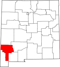 | |
| Towns | ||
| Village | ||
| CDPs | ||
| Other unincorporated communities | ||
| Ghost towns | ||
This article is issued from
Wikipedia.
The text is licensed under Creative Commons - Attribution - Sharealike.
Additional terms may apply for the media files.