Háj u Duchcova
| Háj u Duchcova | |||
|---|---|---|---|
| Municipality | |||
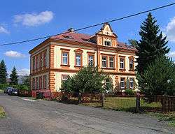 Former school | |||
| |||
 Háj u Duchcova | |||
| Coordinates: 50°37′57″N 13°42′46″E / 50.63250°N 13.71278°ECoordinates: 50°37′57″N 13°42′46″E / 50.63250°N 13.71278°E | |||
| Country |
| ||
| Region | Ústí nad Labem | ||
| District | Teplice | ||
| Area | |||
| • Total | 7.5 km2 (2.9 sq mi) | ||
| Elevation | 158 m (518 ft) | ||
| Population (2006) | |||
| • Total | 1,008 | ||
| • Density | 130/km2 (350/sq mi) | ||
| Postal code | 417 22 | ||
| Website | http://www.ouhaj.cz | ||

Háj u Duchcova (German: Haan bei Dux) is a village and municipality (obec) in Teplice District in the Ústí nad Labem Region of the Czech Republic.
The municipality covers an area of 7.5 square kilometres (2.9 sq mi), and has a population of 1,008 (as of 3 July 2006).
Háj u Duchcova lies approximately 8 kilometres (5 mi) west of Teplice, 24 km (15 mi) west of Ústí nad Labem, and 79 km (49 mi) north-west of Prague.
Gallery
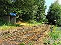 Railway stop
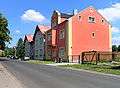 South part of the village
References
| Wikimedia Commons has media related to Háj u Duchcova. |
This article is issued from
Wikipedia.
The text is licensed under Creative Commons - Attribution - Sharealike.
Additional terms may apply for the media files.