Guyatt Park ferry wharf
Guyatt Park | |||||||||||
|---|---|---|---|---|---|---|---|---|---|---|---|
 | |||||||||||
| Location | Hiron Street, St Lucia | ||||||||||
| Coordinates | 27°29′33″S 153°00′07″E / 27.4924°S 153.0019°ECoordinates: 27°29′33″S 153°00′07″E / 27.4924°S 153.0019°E | ||||||||||
| Owned by | Brisbane City Council | ||||||||||
| Operated by | Transdev Brisbane Ferries | ||||||||||
| Platforms | 1 | ||||||||||
| Construction | |||||||||||
| Disabled access | Yes | ||||||||||
| Other information | |||||||||||
| Station code | 317572 | ||||||||||
| Fare zone | go card 1 | ||||||||||
| Services | |||||||||||
| |||||||||||
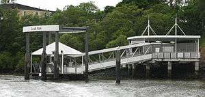
Guyatt Park ferry wharf is located on the southern side of the Brisbane River serving the Brisbane suburb of St Lucia. It is served by Transdev Brisbane Ferries' CityCat services.[1][2]
Description
This wharf comprises a single long pier that ends in a pontoon with two docking stations. However, only one of them is used at a time due to size constraints. This terminal has a covered passenger waiting area with a Telstra pay phone and a drinking water fountain. It takes its name from the adjacent Guyatt Park.
The wharf sustained moderate damage during the January 2011 Brisbane floods.[3] It reopened after repairs on 14 February 2011.[4][5]
References
- ↑ St Lucia wharf timetable TransLink
- ↑ CityCat timetable Transdev Brisbane Ferries
- ↑ List: CityCat, CityFerry terminal damage Brisbane Times 20 January 2011
- ↑ CityCat service set for fast return Brisbane Times 1 February 2011
- ↑ CityCat and CityFerry services Brisbane City Council
External links
![]()
This article is issued from
Wikipedia.
The text is licensed under Creative Commons - Attribution - Sharealike.
Additional terms may apply for the media files.