Guryevsky District, Kaliningrad Oblast
| Guryevsky District Гурьевский район (Russian) | |
|---|---|
.svg.png) Location of Guryevsky District in Kaliningrad Oblast | |
| Coordinates: 54°46′N 20°36′E / 54.767°N 20.600°ECoordinates: 54°46′N 20°36′E / 54.767°N 20.600°E | |
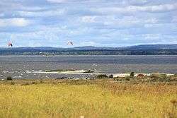 View of the Vistula Lagoon, Guryevsky District | |
.png) |
 |
|
| |
| Location | |
| Country | Russia |
| Federal subject | Kaliningrad Oblast[1] |
| Administrative structure (as of November 2011) | |
| Administrative center | town of Guryevsk[2] |
| Administrative divisions:[2] | |
| Towns of district significance | 1 |
| Rural okrugs | 7 |
| Inhabited localities:[2] | |
| Cities/towns | 1 |
| Rural localities | 146 |
| Municipal structure (as of May 2013) | |
| Municipally incorporated as | Guryevsky Urban Okrug[3] |
| Statistics | |
| Area | 1,284 km2 (496 sq mi)[4] |
| Population (2010 Census) | 52,988 inhabitants[5] |
| • Urban | 23.5% |
| • Rural | 76.5% |
| Density | 41.27/km2 (106.9/sq mi)[6] |
| Time zone | USZ1 (UTC+02:00)[7] |
| Official website | |
| Guryevsky District on WikiCommons | |
Guryevsky District (Russian: Гу́рьевский райо́н) is an administrative district (raion), one of the fifteen in Kaliningrad Oblast, Russia.[1] As a municipal division, it is incorporated as Guryevsky Urban Okrug.[3] It is located in the west of the oblast. The area of the district is 1,284 square kilometers (496 sq mi).[4] Its administrative center is the town of Guryevsk.[2] Population: 52,988 (2010 Census);[5] 47,330 (2002 Census);[8] 39,148 (1989 Census).[9] The population of Guryevsk accounts for 23.5% of the district's total population.[5]
Geography
The district is situated around Kaliningrad, the administrative center of the oblast. For this reason the main railway lines and roads pass through the district.
To the north the district reaches the Curonian Lagoon, to the southwest—the Vistula Lagoon. In the west, parted from the rest of the district by Kaliningrad, the town of Svetly is located on the Vistula Lagoon.
Administrative and municipal status
Within the framework of administrative divisions, Guryevsky District is one of the fifteen in the oblast.[1] The town of Guryevsk serves as its administrative center.[2]
As a municipal division, the district has been incorporated as Guryevsky Urban Okrug since May 31, 2013.[3] Prior to that date, the district was incorporated as Guryevsky Municipal District, which was subdivided into one urban settlement and seven rural settlements.
References
Notes
- 1 2 3 Law #463
- 1 2 3 4 5 Resolution #639
- 1 2 3 Law #229
- 1 2 "General Information" (in Russian). Guryevsky District. Retrieved January 20, 2017.
- 1 2 3 Russian Federal State Statistics Service (2011). "Всероссийская перепись населения 2010 года. Том 1" [2010 All-Russian Population Census, vol. 1]. Всероссийская перепись населения 2010 года (2010 All-Russia Population Census) (in Russian). Federal State Statistics Service. Retrieved June 29, 2012.
- ↑ The value of density was calculated automatically by dividing the 2010 Census population by the area specified in the infobox. Please note that this value is only approximate as the area specified in the infobox does not necessarily correspond to the area of the entity proper or is reported for the same year as the population.
- ↑ Правительство Российской Федерации. Федеральный закон №107-ФЗ от 3 июня 2011 г. «Об исчислении времени», в ред. Федерального закона №271-ФЗ от 03 июля 2016 г. «О внесении изменений в Федеральный закон "Об исчислении времени"». Вступил в силу по истечении шестидесяти дней после дня официального опубликования (6 августа 2011 г.). Опубликован: "Российская газета", №120, 6 июня 2011 г. (Government of the Russian Federation. Federal Law #107-FZ of June 31, 2011 On Calculating Time, as amended by the Federal Law #271-FZ of July 03, 2016 On Amending Federal Law "On Calculating Time". Effective as of after sixty days following the day of the official publication.).
- ↑ Russian Federal State Statistics Service (May 21, 2004). "Численность населения России, субъектов Российской Федерации в составе федеральных округов, районов, городских поселений, сельских населённых пунктов – районных центров и сельских населённых пунктов с населением 3 тысячи и более человек" [Population of Russia, Its Federal Districts, Federal Subjects, Districts, Urban Localities, Rural Localities—Administrative Centers, and Rural Localities with Population of Over 3,000] (XLS). Всероссийская перепись населения 2002 года [All-Russia Population Census of 2002] (in Russian). Retrieved August 9, 2014.
- ↑ Demoscope Weekly (1989). "Всесоюзная перепись населения 1989 г. Численность наличного населения союзных и автономных республик, автономных областей и округов, краёв, областей, районов, городских поселений и сёл-райцентров" [All Union Population Census of 1989: Present Population of Union and Autonomous Republics, Autonomous Oblasts and Okrugs, Krais, Oblasts, Districts, Urban Settlements, and Villages Serving as District Administrative Centers]. Всесоюзная перепись населения 1989 года [All-Union Population Census of 1989] (in Russian). Институт демографии Национального исследовательского университета: Высшая школа экономики [Institute of Demography at the National Research University: Higher School of Economics]. Retrieved August 9, 2014.
Sources
- Калининградская областная Дума. Закон №463 от 27 мая 2010 г. «Об административно-территориальном устройстве Калининградской области», в ред. Закона №450 от 3 июля 2015 г. «О внесении изменений в Закон Калининградской области "Об административно-территориальном устройстве Калининградской области"». Вступил в силу со дня официального опубликования. Опубликован: "Калининградская правда" (вкладыш "Ведомости Правительства Калининградской области"), №112, 26 июня 2010 г. (Kaliningrad Oblast Duma. Law #463 of May 27, 2010 On the Administrative-Territorial Structure of Kaliningrad Oblast, as amended by the Law #450 of July 3, 2015 On Amending the Law of Kaliningrad Oblast "On the Administrative-Territorial Structure of Kaliningrad Oblast". Effective as of the day of the official publication.).
- Правительство Калининградской области. Постановление №640 от 30 августа 2011 г. «Об утверждении реестра объектов административно-территориального деления Калининградской области», в ред. Постановления №877 от 21 ноября 2011 г «О внесении изменения в Постановление Правительства Калининградской области от 30 августа 2011 г. №640». Вступил в силу со дня официального опубликования. Опубликован: "Калининградская правда" (вкладыш "Официально"), №170, 15 сентября 2011 г. (Government of Kaliningrad Oblast. Resolution #640 of August 30, 2011 On the Adoption of the Registry of the Objects of the Administrative-Territorial Divisions of Kaliningrad Oblast, as amended by the Resolution #877 of November 21, 2011 On Amending the Resolution of the Government of Kaliningrad Oblast #640 of August 30, 2011. Effective as of the day of the official publication.).
- Калининградская областная Дума. Закон №229 от 29 мая 2013 г. «Об объединении поселений, входящих в состав Гурьевского муниципального района, и организации местного самоуправления на объединённой территории». Вступил в силу со дня официального опубликования. Опубликован: "Калининградская правда", №92, 31 мая 2013 г.. (Kaliningrad Oblast Duma. Law #229 of May 29, 2013 On Merging the Settlements Within Guryevsky Municipal District and on the Organization of the Local Self-Government on the United Territory. Effective as of the day of the official publication.).
| Districts | ||
|---|---|---|
| Cities and towns | ||
| Urban-type settlements of oblast significance | ||
| Urban-type settlements | ||