Curonian Lagoon
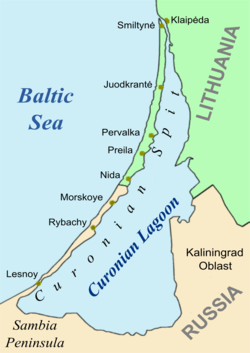
The Curonian Lagoon (or Bay, Gulf; Russian: Куршский залив, Lithuanian: Kuršių marios, Polish: Zalew Kuroński, German: Kurisches Haff, Latvian: Kuršu joma) is separated from the Baltic Sea by the Curonian Spit. Its surface area is 1,619 square kilometers (625 sq mi).[1] The Neman River (Lithuanian: Nemunas) supplies about 90% of its inflows; its watershed consists of about 100,450 square kilometres in Lithuania and Russia's Kaliningrad Oblast.[2]
Human history
In the 13th century, the area around the lagoon was part of the ancestral lands of the Curonians and Old Prussians. Later it bordered the historical region of Lithuania Minor. At the northern end of the Spit, there is a passage to the Baltic Sea, and the place was chosen by the Teutonic Knights in 1252 to found Memelburg castle and the city of Memel — officially called Klaipėda in 1923-39, when the Memel Territory was separated from Germany, and again after 1945, when it became part of the Lithuanian SSR.
As the new interwar border, the river that flows into the Curonian Lagoon near Rusnė (German: Ruß) was chosen. The river's lower 120 km in Germany were called die Memel by Germans, while the upper part located in Lithuania was known as Nemunas River. The border also separated the peninsula near the small holiday resort of Nida, Lithuania (German: Nidden); the southern part of the Spit and the Lagoon remained in Germany until 1945.
This border is now the border between Lithuania and Russia, as after World War II, the southern end of the Spit and the German area south of the river — the part of East Prussia with the city Königsberg in Sambia — became part an exclave of Russia called Kaliningrad Oblast.
Kursenieki
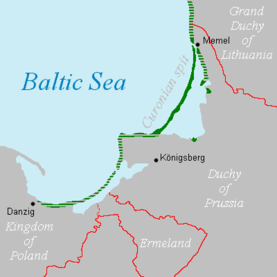
While today the Kursenieki, also known as Kuršininkai, are a nearly extinct Baltic ethnic group living along the Curonian Spit, in 1649 Kuršininkai settlement spanned from Memel (Klaipėda) to Danzig (Gdańsk). The Kuršininkai were eventually assimilated by the Germans, except along the Curonian Spit where some still live. The Kuršininkai were considered Latvians until after World War I, when Latvia gained independence from the Russian Empire, a consideration based on linguistic arguments. This was the rationale for Latvian claims over the Curonian Spit, Memel, and other territories of East Prussia which would be later dropped.
Natural history and ecology
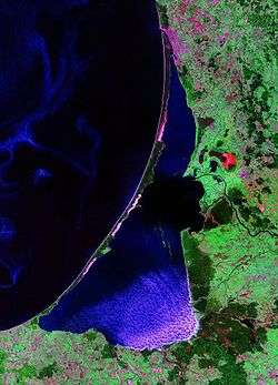
The Lagoon, formed about 7,000 years BCE, is a freshwater lagoon.[3] Water depths average 3.8 meters.[4] It is highly biodiverse, although troubled by water pollution.[3] The presence of algal blooms was confirmed in the 2000s.[4]
See also
References
- ↑ "Curonian Lagoon". Encyclopædia Britannica. Retrieved 2009-10-17.
- ↑ I. Ethem Gönenç, Angheluta Vadineanu (2008). Sustainable Use and Development of Watersheds. Springer. ISBN 978-1-4020-8557-4.
- 1 2 "Site name:Lithuanian coastal site". Vilnius University Ecological Institute. Archived from the original on 2011-07-20. Retrieved 2009-10-17.
- 1 2 "Toxic cyanobacteria blooms in the Lithuanian part of the Curonian Lagoon" (PDF). Institute of Oceanology of the Polish Academy of Sciences. Retrieved 2009-10-17.
External links
- Kurische Nehrung (German)
Coordinates: 55°05′34″N 20°54′59″E / 55.09278°N 20.91639°E
Tributaries of the Neman River | ||
|---|---|---|
| Main tributaries of the left bank |
|  |
| Main tributaries of the right bank | ||
| Distributary |
| |
| Authority control |
|---|