Guruwar Peth, Pune
Coordinates: 18°30′20″N 73°51′39″E / 18.505555°N 73.860755°E
| Guruwar Peth | |
|---|---|
| Neighbourhood | |
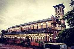 The most iconic structure seen in Guruwar Peth: The Holy Church Of The Holy Name and its Bell Tower | |
| Country |
|
| State | Maharashtra |
| District | Poona |
| Taluka | Havelli |
| Established | 1625 |
| Founded by | Shahaji |
| Named for | "Thursday" in Marathi |
| Government | |
| • Type | Municipal Corporation |
| Area | |
| • Total | 253.684 km2 (97.948 sq mi) |
| Elevation | 549 m (1,801 ft) |
| Population (2006) | |
| • Total | approx. 9,500 |
| Time zone | UTC+5:30 (IST) |
| Postcode | 411042 |
| Telephone code | 020 |
Guruwar Peth is an area located in Pune (Old) City, in Maharashtra State of the Republic of India.
Location
Places adjacent to Guruwar Peth, Pune | ||||||||||
|---|---|---|---|---|---|---|---|---|---|---|
| ||||||||||
References

This article is issued from
Wikipedia.
The text is licensed under Creative Commons - Attribution - Sharealike.
Additional terms may apply for the media files.