Gunnison River Bridges I & II
|
Gunnison River Bridge I Gunnison River Bridge II | |
| Location | Gunnison, Colorado |
|---|---|
| Area | less than one acre |
| NRHP reference # | 02001151 and 02001152 |
| Added to NRHP | October 15, 2002 |
Gunnison River Bridge I and Gunnison River Bridge II are two 129 feet (39 m) long bridges built during 1926-27.[1][2] They were separately listed on the National Register of Historic Places in 2002.
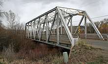
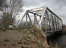
The bridges carry what is now the U.S. Highway 50 service road. Bridge I brings it over Gunnison River overflow at mileposts 155.41 and Bridge II, at 155.59, brings it over the Gunnison River proper.[1][2]
The bridges are located at 38°31′58″N 106°57′08″W / 38.532711°N 106.952259°W (Bridge I, further to the west, spanning overflow) and 38°32′02″N 106°56′57″W / 38.533947°N 106.949168°W (Bridge II, further to the east, spanning the main river).
The two bridges are Pratt truss through truss bridges, 129 feet (39 m) long. Their trusses were fabricated by the American Bridge Company.[1][2]
See also
References
- 1 2 3 Office of Archaeology and Historic Preservation; Clay Fraser (May 21, 2002). "National Register of Historic Places Registration: Gunnison River Bridge I / CDOT No. J-09-C / 5GN3321". National Park Service. Retrieved October 1, 2018. With two photos from 1998.
- 1 2 3 Office of Archaeology and Historic Preservation; Clay Fraser (May 21, 2002). "National Register of Historic Places Registration: Gunnison River Bridge II / CDOT No. J-09-C / 5GN3322". National Park Service. Retrieved October 1, 2018. With two photos from 1998.
| Topics | |
|---|---|
| Lists by states |
|
| Lists by insular areas | |
| Lists by associated states | |
| Other areas | |
| |