Guna, India
| Guna | |
|---|---|
| City | |
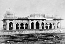 Guna railway station, 1890 | |
 Guna Location in Madhya Pradesh, India  Guna Guna (India) | |
| Coordinates: 24°39′N 77°19′E / 24.65°N 77.32°ECoordinates: 24°39′N 77°19′E / 24.65°N 77.32°E | |
| Country |
|
| State | Madhya Pradesh |
| District | Guna |
| Area | |
| • Total | 84 km2 (32 sq mi) |
| Elevation | 474 m (1,555 ft) |
| Population (2011) | |
| • Total | 180,978 |
| • Density | 2,155/km2 (5,580/sq mi) |
| Languages | |
| • Official | Hindi, English |
| Time zone | UTC+5:30 (IST) |
| PIN | 473001 |
| Telephone code | 91 7542 |
| ISO 3166 code | IN-MP |
| Vehicle registration | MP-08 |
| Sex ratio | 910 ♂/♀ |
Guna is a city and a municipality in Guna district in the Indian state of Madhya Pradesh. It is the administrative headquarters of Guna District and is located on the banks of Parbati river.
Geography
Guna is located at 24°39′N 77°19′E / 24.65°N 77.32°E.[1] It has an average elevation of 474 metres (1555 ft).
Demographics
As of 2011 India census,[2] Guna has a population of 180,978. Males constitute 52.29% of the population and females 47.71%. Guna has an average literacy rate of 81.7%, In Guna, 13% of the population is under 6 years of age.
References
- ↑ Falling Rain Genomics, Inc - Guna
- ↑ "Census of India 2001: Data from the 2001 Census, including cities, villages and towns (Provisional)". Census Commission of India. Archived from the original on 2004-06-16. Retrieved 2008-11-01.
External links
This article is issued from
Wikipedia.
The text is licensed under Creative Commons - Attribution - Sharealike.
Additional terms may apply for the media files.