Guhagar
| Guhagar | |
|---|---|
| city | |
 Guhagar Location in Maharashtra, India | |
| Coordinates: 17°28′N 73°12′E / 17.47°N 73.2°ECoordinates: 17°28′N 73°12′E / 17.47°N 73.2°E | |
| Country |
|
| State | Maharashtra |
| District | Ratnagiri |
| Elevation | 10 m (30 ft) |
| Population (2001) | |
| • Total | 3,205 |
| Languages | |
| • Official | Marathi |
| Time zone | UTC+5:30 (IST) |
| PIN | 415703 |
| Telephone code | 02359 |
| Vehicle registration | MH-08 |
Guhagar is a census city in Ratnagiri district in the Indian state of Maharashtra. Guhagar is known for its virgin beach, coir items, coconuts, betel nuts and mainly Haapus Alphonso mangoes. The nearest city and railhead is Chiplun, about 44 kilometres (27 mi) away. The economy of Guhagar boomed after the Dabhol Power Company, a few kilometres north was commissioned in the early 1990s. Hotels sprung up and residents were given well-paid jobs.
Guhagar is famous for Durga Devi temple, Guhagar and Vyadeshwar temple.[1]
Geography
A word Guhagar means cave house in local language Guhagar is located at 17°28′N 73°12′E / 17.47°N 73.2°E.[2] It has an average elevation of 10 metres (33 feet). Guhagar has been featured in several films, the recent one being the Marathi Film Killa (film)
Demographics
As of 2001 India census,[3] Guhagar had a population of 3205. Males constitute 52% of the population and females 48%. Guhagar has an average literacy rate of 82%, higher than the national average of 59.5%: male literacy is 86%, and female literacy is 78%. In Guhagar, 10% of the population is under 6 years of age.
Gallery
.jpg) View of Guhagar Beach
View of Guhagar Beach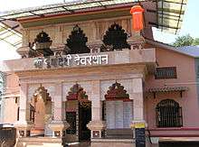 Durga Devi Temple
 Pindi of Shri Vyadeshwar
 Shri Vyadeshwar Aarti
References
| Wikimedia Commons has media related to Guhagar. |
| Wikivoyage has a travel guide for Guhagar. |
- ↑ "Guhagar". India: Puneri Travellers. 3 November 2014.
- ↑ Falling Rain Genomics, Inc - Guhagar
- ↑ "Census of India 2001: Data from the 2001 Census, including cities, villages and towns (Provisional)". Census Commission of India. Archived from the original on 2004-06-16. Retrieved 2008-11-01.
Ratnagiri district topics | ||
|---|---|---|
| Geography |  | |
| Flora and Fauna | ||
| Cities and towns | ||
| Transport | ||
| Lok Sabha constituencies | ||
| Vidhan Sabha constituencies | ||
| Talukas | ||