Guggernell
| Guggernell | |
|---|---|
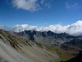 The Guggernellgrat (centre-right) and the Guggernell (right) | |
| Highest point | |
| Elevation | 2,744 m (9,003 ft) |
| Prominence | 64 m (210 ft) [1] |
| Parent peak | Guggernellgrat |
| Coordinates | 46°43′20.8″N 9°39′12.4″E / 46.722444°N 9.653444°ECoordinates: 46°43′20.8″N 9°39′12.4″E / 46.722444°N 9.653444°E |
| Geography | |
 Guggernell Location in Switzerland | |
| Location | Graubünden, Switzerland |
| Parent range | Plessur Range |
The Guggernell is a mountain of the Plessur Alps, located south of Arosa in the canton of Graubünden. It lies west of the Guggernellgrat.
References
- ↑ Retrieved from the Swisstopo topographic maps and Google Earth. The key col is located east of the summit at 2,680 metres.
External links
This article is issued from
Wikipedia.
The text is licensed under Creative Commons - Attribution - Sharealike.
Additional terms may apply for the media files.