Guanabara (state)
| State of Guanabara | |||
|---|---|---|---|
| Former State | |||
| |||
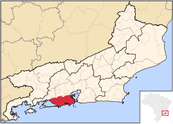 Location of the state of Rio de Janeiro (light yellow) and the now-defunct state of Guanabara (red) in Brazil. | |||
| Coordinates: 22°54′S 43°11′W / 22.900°S 43.183°WCoordinates: 22°54′S 43°11′W / 22.900°S 43.183°W | |||
| Country |
| ||
| Established | 1960 | ||
| Dissolved | 1975 | ||
| Government | |||
| • Governor | Antônio de Pádua Chagas Freitas (last governor, 1971–75) | ||
| Area | |||
| • Total | 1,356 km2 (524 sq mi) | ||
| Population | |||
| • Estimate (1975) | 4,858,000 | ||
| Time zone | UTC-3 (BRT) | ||
| • Summer (DST) | UTC-2 (BRST) | ||
| ISO 3166 code | BR-GB | ||
.png)
.png)
The State of Guanabara (Portuguese: Estado da Guanabara, IPA: [ɡwanaˈbaɾa]) was a State of Brazil from 1960 to 1975, which existed in the territory of the current municipality of Rio de Janeiro. In its area, was located the old Federal District.
Etymology
The State of Guanabara shares its name with Guanabara Bay, which lies to the east of the state. There are many theories as to the name's origins, including hidden water[1], lagoon of the sea[2], and bosom of the sea.[3]
History
In 1834, the city of Rio de Janeiro was elevated to Imperial capital of the Empire of Brazil, and was included in the Neutral Municipality (Portuguese: Município Neutro). The surrounding Province of Rio de Janeiro (which did not include the city) had its capital city in Niterói. When Brazil became a republic in 1889, the city of Rio de Janeiro remained the national capital, and the territory of the Neutral Municipality became the Federal District (Portuguese: Distrito Federal), while the surrounding homonymous province became a state, still with Niterói as its capital.
When the national capital was moved to Brasília in 1960, and a new Federal District was created for it, the old Federal District became the state of Guanabara.[1]
Throughout its 15-year existence, Guanabara was a unique state in many ways. Comprising only one city (albeit a large one), Guanabara was the smallest Brazilian state by land. It also had the peculiarity of being the only Brazilian state that was not divided into municipalities. There was no mayor, municipal legislature or any other municipal government institution there, as the city of Rio de Janeiro was directly administered by the state government of Guanabara. On the other hand, that also meant that the Guanabara state government had some functions that were normally assigned to municipalities elsewhere, such as regulating urban zoning, inspecting the safety of buildings, or issuing licenses for commercial venues, for example.
All the characteristics disappeared in 1975, when the state of Guanabara merged into the state of Rio de Janeiro. With the merge, the capital of the state of Rio de Janeiro was transferred back from city of Niterói to city of Rio de Janeiro, as it was until 1834 when the empire created the Neutral Municipality.
Electoral history
In gubernatorial elections held on 3 October 1965, Francisco Negrão de Lima, a candidate supported by a coalition formed by PTB and PSD and a close associate of former President Juscelino Kubitschek, won the race to be the state's governor, garnering 52% of the votes cast.[4]
References
- 1 2 Franco, Paulo (2014). Diversity – The Brazilian Essence: Knowing Brazil By the Culture of Their People. pp. 47–49. Retrieved 3 January 2018.
- ↑ DK Eyewitness Travel Guide Brazil (First American Edition, 2007 ed.). p. 92. Retrieved 3 January 2018.
- ↑ Museum of Tomorrow (PDF). p. 47. Retrieved 3 January 2018.
Of the indigenous tribes that lived along its banks, there are now only reports, a few middens and the original Tupi-Guarani names that continue to identify the geographical features and places along its shores, starting with its own name, Guanabara, or "bosom of the sea"...
- ↑ Alves, Maria Helena Moreira (1985). State and Opposition in Military Brazil. The University of Texas Press. Retrieved 3 January 2018.