Grorud Valley
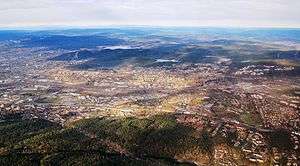
The Grorud Valley[1][2][3] (Norwegian: Groruddalen) is a broad valley in eastern Oslo. Four of Oslo's boroughs lie within the Grorud Valley; Bjerke in the west, Alna in the south, Grorud in the north, and Stovner in the east.[4]
The population of the Grorud Valley is around 165,000 (more than a quarter of the total population of Oslo), while there are about 60,000 people employed there. The main population centers are on the valley sides, close to the forest of Lillomarka and Østmarka. The valley basin has fewer houses but a fair amount of industry. Thanks to large scale urbanization throughout the valley in the 1960s and 1970s, the population increased by almost 70% between 1960 and 1990. Generally the neighborhoods are well maintained and there are recreational facilities and open spaces in the Grorud Valley.[5]
The Grorud Valley is served by several motorways and rail lines running along the valley. In the south of the valley is the European route E6 highway and the subway line Furusetbanen. The central valley is served by Norwegian Route 163 (Østre Aker vei) as well as Hovedbanen rail line. The north side is served by Norwegian Route 4 (Trondheimsveien) and the subway line Grorudbanen. There are also roads and bus lines which run across the valley, but the cross-valley communications are often considered inadequate.
References
- ↑ Berger, Alan; Kotkin, Joel; Balderas-Guzmán, Celina (2017). Infinite Suburbia. New York: Princeton Architectural Press. p. 149.
- ↑ Bengt Andersen; Per Gunnar Røe; Oddrun Sæter. "Trust and Distrust in Oslo". Social Transformations in Scandinavian Cities: Nordic Perspectives on Urban Marginalization and Social Sustainability. Lund: Nordic Academic Press. p. 115.
- ↑ Almaas, Ingerid Helsing (2016). Made in Norway: New Norwegian Architecture. Oslo: Architektur N. p. 120.
- ↑ "Groruddalen". lokalhistoriewiki. Retrieved May 1, 2018.
- ↑ Knut Are Tvedt. "Groruddalen". Store norske leksikon. Retrieved May 1, 2018.
Other sources
- Eivind Heide (1980) Groruddalen (Oslo: Tiden Norsk Forlag) ISBN 9788210019074
External links
- Official Grorud Valley Action project site
- Social challenges (Norwegian article)