Bjerke
| Bydel Bjerke | ||
|---|---|---|
| District | ||
| ||
 | ||
| Country | Norway | |
| City | Oslo | |
| District | Grorud Valley | |
| Area | ||
| • Total | 7.72 km2 (2.98 sq mi) | |
| Population (2012) | ||
| • Total | 29,090 | |
| • Density | 3,768/km2 (9,760/sq mi) | |
| Time zone | UTC+1 (CET) | |
| • Summer (DST) | UTC+2 (CEST) | |
| ISO 3166 code | NO-030109 | |
| Website | bbj.oslo.kommune.no | |

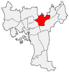
Bjerke is a borough of the city of Oslo, Norway.
The most densely populated residential areas, including the high-rise apartment blocks of Linderud, are located along Trondheimsveien (Norwegian National Road 4). The shopping centre at Linderud is also home to the borough council's administrative headquarters. The northern areas of the borough are bordered by the vast woodlands of Oslomarka. Bjerke Upper Secondary School is located here.
Districts
- Linderud
- Lofthus (on the border with Nordre Aker borough)
- Tonsenhagen
- Årvoll
- Veitvet
- Økern
- Risløkka
Coordinates: 59°56′25″N 10°48′50″E / 59.94028°N 10.81389°E
This article is issued from
Wikipedia.
The text is licensed under Creative Commons - Attribution - Sharealike.
Additional terms may apply for the media files.