Grinnell, Kansas
| Grinnell, Kansas | |
|---|---|
| City | |
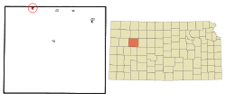 Location within Gove County and Kansas | |
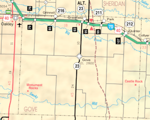 KDOT map of Gove County (legend) | |
| Coordinates: 39°7′26″N 100°37′47″W / 39.12389°N 100.62972°WCoordinates: 39°7′26″N 100°37′47″W / 39.12389°N 100.62972°W | |
| Country | United States |
| State | Kansas |
| County | Gove |
| Area[1] | |
| • Total | 0.51 sq mi (1.32 km2) |
| • Land | 0.51 sq mi (1.32 km2) |
| • Water | 0 sq mi (0 km2) |
| Elevation | 2,910 ft (887 m) |
| Population (2010)[2] | |
| • Total | 259 |
| • Estimate (2016)[3] | 238 |
| • Density | 510/sq mi (200/km2) |
| Time zone | UTC-6 (Central (CST)) |
| • Summer (DST) | UTC-5 (CDT) |
| ZIP code | 67738 |
| Area code(s) | 785 |
| FIPS code | 20-28900 [4] |
| GNIS feature ID | 0471312 [5] |
Grinnell is a city in Gove County, Kansas, United States. As of the 2010 census, the city population was 259.[6]
History
Grinnell was named for businessman Moses Hicks Grinnell.[7]
The first newspaper in Grinnell was the Golden Belt, in 1885.[8]
Geography
Grinnell is located at 39°7′26″N 100°37′47″W / 39.12389°N 100.62972°W (39.123999, -100.629852).[9] According to the United States Census Bureau, the city has a total area of 0.51 square miles (1.32 km2), all of it land.[1]
Demographics
| Historical population | |||
|---|---|---|---|
| Census | Pop. | %± | |
| 1920 | 162 | — | |
| 1930 | 303 | 87.0% | |
| 1940 | 289 | −4.6% | |
| 1950 | 364 | 26.0% | |
| 1960 | 396 | 8.8% | |
| 1970 | 449 | 13.4% | |
| 1980 | 410 | −8.7% | |
| 1990 | 348 | −15.1% | |
| 2000 | 329 | −5.5% | |
| 2010 | 259 | −21.3% | |
| Est. 2016 | 238 | [3] | −8.1% |
| U.S. Decennial Census | |||
2010 census
As of the census[2] of 2010, there were 259 people, 135 households, and 81 families residing in the city. The population density was 507.8 inhabitants per square mile (196.1/km2). There were 156 housing units at an average density of 305.9 per square mile (118.1/km2). The racial makeup of the city was 100.0% White. Hispanic or Latino of any race were 0.4% of the population.
There were 135 households of which 14.1% had children under the age of 18 living with them, 54.8% were married couples living together, 3.7% had a female householder with no husband present, 1.5% had a male householder with no wife present, and 40.0% were non-families. 38.5% of all households were made up of individuals and 18.6% had someone living alone who was 65 years of age or older. The average household size was 1.92 and the average family size was 2.48.
The median age in the city was 55.9 years. 13.5% of residents were under the age of 18; 5% were between the ages of 18 and 24; 16.6% were from 25 to 44; 32.8% were from 45 to 64; and 32% were 65 years of age or older. The gender makeup of the city was 52.1% male and 47.9% female.
2000 census
As of the census[4] of 2000, there were 329 people, 149 households, and 87 families residing in the city. The population density was 662.2 people per square mile (254.1/km²). There were 158 housing units at an average density of 318.0 per square mile (122.0/km²). The racial makeup of the city was 99.70% White and 0.30% African American. Hispanic or Latino of any race were 0.61% of the population.
There were 149 households out of which 19.5% had children under the age of 18 living with them, 51.7% were married couples living together, 4.0% had a female householder with no husband present, and 41.6% were non-families. 39.6% of all households were made up of individuals and 28.2% had someone living alone who was 65 years of age or older. The average household size was 2.21 and the average family size was 2.98.
In the city, the population was spread out with 22.5% under the age of 18, 7.6% from 18 to 24, 19.5% from 25 to 44, 21.6% from 45 to 64, and 28.9% who were 65 years of age or older. The median age was 45 years. For every 100 females, there were 104.3 males. For every 100 females age 18 and over, there were 105.6 males.
The median income for a household in the city was $35,833, and the median income for a family was $41,750. Males had a median income of $27,167 versus $21,500 for females. The per capita income for the city was $20,056. About 9.2% of families and 8.2% of the population were below the poverty line, including 8.5% of those under age 18 and 8.6% of those age 65 or over.
Education
USD 291 Grinnell has a cooperative agreement with USD 292 Wheatland to educate high school students at Wheatland High School.[10] The Wheatland High School mascot is a Thunderhawk.[11]
Grinnell High School was closed with the cooperative agreement.
The Grinnell Warriors[12] won the following Kansas State High School championships:
- 1974 Boys Basketball - Class 1A [13]
- 1976 Girls Volleyball - Class 1A [14]
- 1979 Girls Volleyball - Class 1A [14]
- 1981 Girls Volleyball - Class 1A [14]
- 1982 Girls Volleyball - Class 1A [14]
- 1985 Girls Basketball - Class 1A [13]
- 1987 Girls Volleyball - Class 1A [14]
- 1988 Girls Volleyball - Class 1A [14]
Notable people
References
- 1 2 "US Gazetteer files 2010". United States Census Bureau. Archived from the original on 2012-01-24. Retrieved 2012-07-06.
- 1 2 "American FactFinder". United States Census Bureau. Retrieved 2012-07-06.
- 1 2 "Population and Housing Unit Estimates". Retrieved June 9, 2017.
- 1 2 "American FactFinder". United States Census Bureau. Archived from the original on 2013-09-11. Retrieved 2008-01-31.
- ↑ "US Board on Geographic Names". United States Geological Survey. 2007-10-25. Retrieved 2008-01-31.
- ↑ "2010 City Population and Housing Occupancy Status". U.S. Census Bureau. Archived from the original on July 21, 2011. Retrieved September 1, 2011.
- ↑ Heim, Michael (2007). Exploring Kansas Highways. p. 29. ISBN 9780974435886.
- ↑ Blackmar, Frank Wilson (1912). Kansas: A Cyclopedia of State History, Embracing Events, Institutions, Industries, Counties, Cities, Towns, Prominent Persons, Etc. Standard Publishing Company. p. 797.
- ↑ "US Gazetteer files: 2010, 2000, and 1990". United States Census Bureau. 2011-02-12. Retrieved 2011-04-23.
- ↑ "High School - USD 291". USD 291. Retrieved 4 January 2017.
- ↑ "USD 292 Wheatland". USD 292. Retrieved 4 January 2017.
- ↑ "Grinnell Warriors", Hays Daily News, 11 September 1975, p.19.
- 1 2 "Basketball". KSHSAA. Retrieved 3 January 2017.
- 1 2 3 4 5 6 "Volleyball". KSHSAA. Retrieved 3 January 2017.
External links
| Wikimedia Commons has media related to Grinnell, Kansas. |
- City
- Schools
- USD 291, local school district
- Maps
- Grinnell City Map, KDOT
Municipalities and communities of Gove County, Kansas, United States | ||
|---|---|---|
| Cities | 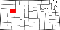 | |
| Ghost towns | ||
| Townships | ||
| Footnotes | ‡This populated place also has portions in an adjacent county or counties | |